Upper Mustang Trek - 16 Days
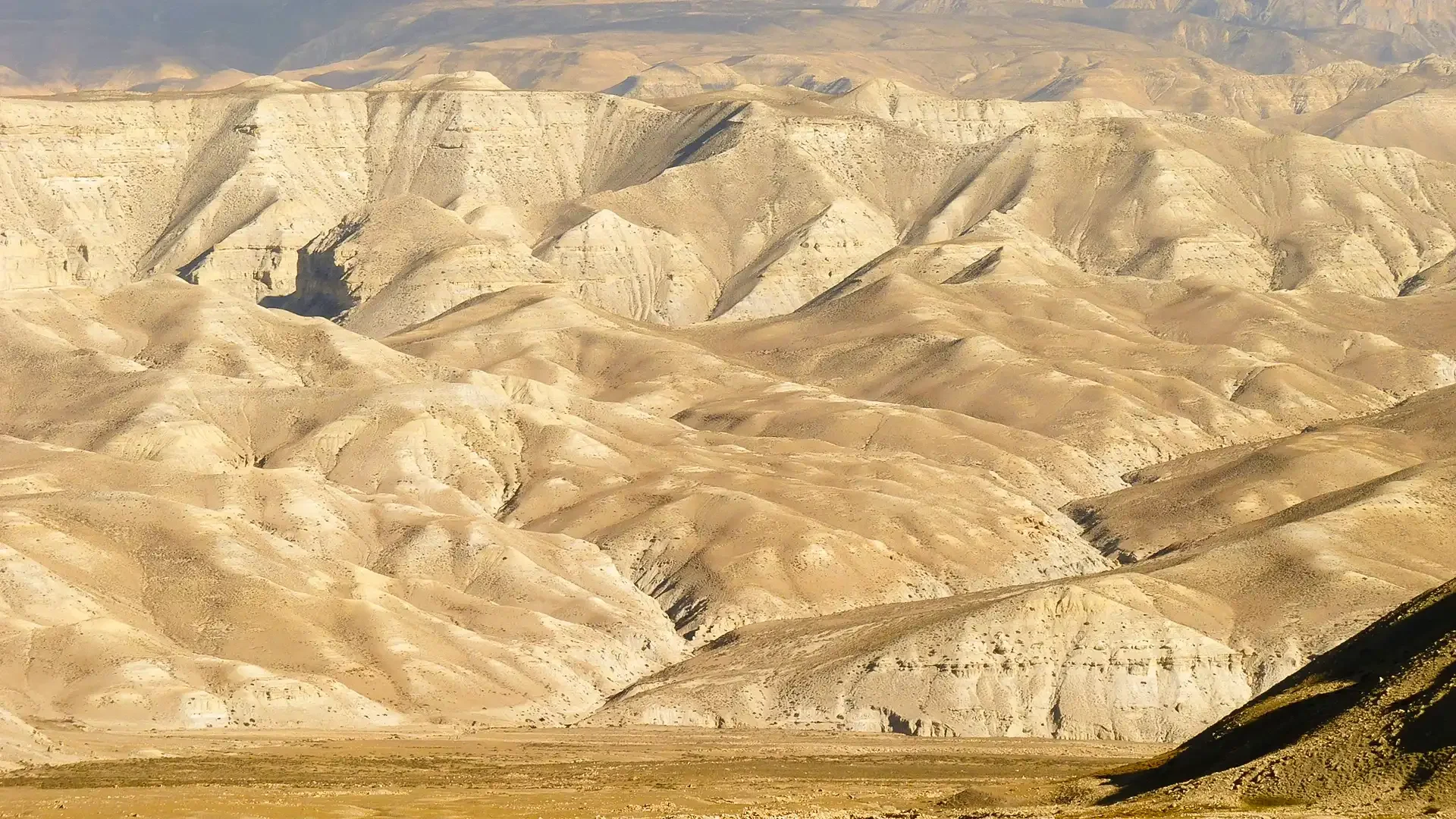
The Upper Mustang Trek - 16 Days is Nepal’s most complete journey into the last forbidden kingdom, offering extended time for cultural immersion and exploration. This trek visits remote villages and ancient sites where medieval Tibetan culture has remained remarkably preserved. The route passes through striking high-altitude desert landscapes of ochre, red, and grey cliffs, deep canyons, and wide open valleys. Lo Manthang, the walled capital, features a royal palace and centuries-old monasteries, providing a living museum of Tibetan Buddhist heritage. Trekking also includes mysterious sky caves carved into cliffs over 2,000 years ago. These ancient sites reveal traditional meditation and burial practices still observed by local communities. Villagers of Ghyakar, Samar, and other remote settlements maintain authentic Tibetan Buddhist lifestyles. Travelers can interact with the Loba people and witness centuries-old customs largely unchanged by modern tourism. The extended itinerary allows more time for photography, capturing the desert landscapes at different times of day. It also offers a relaxed pace and better acclimatization compared to shorter treks. The maximum altitude is 3,850m at Yamda La Pass, making it accessible to fit trekkers without extreme high-altitude risk. Spring (March–May) and autumn (September–November) are ideal, and the region’s rain shadow allows trekking even during monsoon season. This 16-day Upper Mustang Trek is perfect for culture enthusiasts, photographers, and travelers seeking unhurried exploration. It combines spectacular landscapes, living heritage, and intimate access to one of Nepal’s most extraordinary hidden kingdoms. General Information Detail Information Region Mustang (Annapurna), Nepal Start/End Point Jomsom (via Pokhara) Best Season March-May, September-November (also June-August) Group Size Minimum 2 (restricted area requirement) Guide Mandatory (restricted area) Special Permit Upper Mustang Restricted Area Permit required Why Choose Nepal Visuals For The 16 Day Upper Mustang Trek? Sixteen days to experience Upper Mustang without compromise. More time in the forbidden kingdom means unhurried days in Lo Manthang, deeper encounters with Loba communities, and space to explore remote monasteries and canyon landscapes that shorter itineraries can only skim. Restricted area permits handled from start to finish. Upper Mustang requires a tightly controlled permit, a mandatory licensed guide, and careful documentation at multiple checkpoints. We manage every layer of the process so your access to this protected corridor is never left to chance. Lo Manthang given the days it actually deserves. The ancient walled capital is the heart of this trek and our itinerary reflects that. Multiple days in and around Lo Manthang allow its royal palace, living monasteries, and centuries-old lanes to reveal themselves at a natural pace. Cave monasteries and sky caves included, not rushed past. Sites like Luri Gompa, Chungsi Cave, and the Mustang sky caves are among the most extraordinary archaeological treasures in the Himalayas. Our guides know each one well and build genuine time into the schedule to explore them properly. Complete and honest pricing before any permits are filed. Upper Mustang carries some of the highest permit fees in Nepal trekking. We present the full cost of your 16 days, every permit, transfer, accommodation, and guide fee, clearly and upfront so your budget holds firm throughout. All logistics confirmed well before you reach Jomsom. The Pokhara to Jomsom flight, teahouse bookings for all 16 nights, and every transfer along the restricted zone are arranged in advance so the journey begins cleanly and nothing important is left unresolved on arrival. Loba culture encountered with genuine depth. Sixteen days creates room for real community engagement, monastery visits with local monks, and time in villages that see very few outside visitors. Our guides approach every encounter with the respect and local knowledge it requires. Support maintained across one of Nepal's most remote routes. Connectivity in Upper Mustang is limited and stretches of the trail are genuinely isolated. Our team stays reachable via WhatsApp, Email, and Zoom throughout all 16 days so a reliable point of contact is always available. Your departure is guaranteed the moment you book. Sixteen days in a restricted Himalayan kingdom deserves an unconditional commitment from the people organising it. Every confirmed 16-day Upper Mustang booking departs as planned, regardless of group size, without exception.
- Duration: 16 days
- Difficulty: Moderate
- Category: Adventure
- Accommodation: Hotels & Tea Houese
- Meals: B, L, D During Trek
- Max Altitude: 3,850m
- Trek Distance: 140 km / 87 miles
- Transportation: Tourist bus/jeep & flight
Region: Mustang Region
Itinerary
Day : Arrive in Kathmandu (1,400m)
Your Nepal Visuals representative meets you at Tribhuvan International Airport and transfers you to your hotel in Thamel. Welcome briefing over dinner this evening.
Day : Drive Kathmandu to Pokhara (822m)
Scenic drive along the Prithvi Highway through terraced hillsides, the Trishuli River valley, and traditional villages. Arrive Pokhara late afternoon. Evening free at Phewa Lake.
Day : Drive Pokhara to Jomsom (2,710m) and Trek to Kagbeni (2,804m)
Early morning drive through the Kali Gandaki gorge to Jomsom, the gateway to Upper Mustang. A short afternoon trek brings you to Kagbeni, the medieval gateway village where restricted area permits are checked. Explore the ancient red-walled monastery and windswept chortens.
Day : Trek from Kagbeni (2,804m) to Chele (3,070m)
Begin your journey deeper into Upper Mustang. The trail takes you through narrow valleys and rocky terrain. Pass through villages like Tangbe with whitewashed homes typical of the Upper Mustang trekking route. Arrive in Chele with breathtaking views of the surrounding peaks.
Day : Trek from Chele (3,070m) to Geling (3,500m)
A beautiful mix of rugged cliffs and tranquil juniper forests. Pass through Samar village and experience the quiet beauty of Upper Mustang. After 5-6 hours arrive in Geling, where peaceful surroundings invite reflection on the stunning landscapes and ancient culture encountered so far.
Day : Trek from Geling (3,500m) to Charang (3,620m)
Trek through the high plateau of Lo, passing ancient chortens and prayer walls. The landscape is otherworldly: deep red and ochre cliffs, wind-carved formations, and a silence that feels almost sacred. Arrive in Charang, a historic village with a 400-year-old dzong and monastery perched above the valley.
Day : Trek from Charang (3,620m) to Lo Manthang (3,840m)
Arrive at Lo Manthang, the walled capital of the Forbidden Kingdom of Mustang. Walk through the single gate into a medieval city largely unchanged for 600 years. White-washed buildings, butter lamp-lit monasteries, and the Mustang royal palace rise together within the ancient walls. Visit the Thubchen and Jampa Lhakhangs.
Day : Rest and Explore Lo Manthang (3,840m)
A full day to explore Lo Manthang. Visit Thubchen Gompa, Jampa Lhakhang, and the royal palace. Optional excursion to the ancient cliff caves of Chhoser Village, sky caves carved into vertical canyon walls over 3,000 years ago. The afternoon is yours to wander and absorb this extraordinary place.
Day : Trek Lo Manthang to Ghami (3,500m)
Begin the return journey south. Pass through Marang and descend to Ghami, a prosperous village with a 400-metre-long mani wall, one of the longest in Nepal, and a dramatic red cliff backdrop.
Day : Trek Ghami to Tsarang (3,620m)
A relatively easy day through the high Mustang plateau. Visit Tsarang Monastery and the crumbling Tsarang Dzong, once the second most important fortress in the kingdom. Views west toward Dhaulagiri on a clear day are extraordinary.
Day : Trek Tsarang to Chhusang (2,950m) via Shyangmochen
Continue back toward Jomsom, passing through villages as you descend. Enjoy views of the Kali Gandaki River and surrounding peaks. After 5-6 hours reach Chhusang, a quiet village at the river confluence.
Day : Trek Chhusang to Muktinath (3,800m) via Kagbeni
Descend to Kagbeni then climb to Muktinath, one of the most sacred pilgrimage sites for Hindus and Buddhists alike. The temple complex has 108 water spouts and an eternal flame. The Dhaulagiri-Annapurna panorama from here is unforgettable at sunrise.
Day : Trek from Muktinath (3,800m) to Jomsom (2,700m)
Begin your descent back to Jomsom, passing through Kagbeni and following the Kali Gandaki River. Arrive in Jomsom where you can relax and celebrate the completion of your Upper Mustang journey.
Day : Fly Jomsom to Pokhara, Drive to Kathmandu
Morning flight from Jomsom to Pokhara with panoramic Annapurna and Dhaulagiri views. Board a tourist bus for the drive back to Kathmandu. Arrive evening for a farewell dinner.
Day : Drive Pokhara to Kathmandu
Drive back to Kathmandu along the Prithvi Highway, passing through lush valleys and terraced hills for one last look at Nepal. Arrive Kathmandu in the evening.
Day : Departure from Kathmandu
Our representative transfers you to Tribhuvan International Airport for your flight home. Reflect on your journey through the Forbidden Kingdom, a world apart and yours to carry forever.
Essential Gear
Hygiene and Safety Essentials
Biodegradable Soap : Safe for the scarce and fragile water sources across the arid Upper Mustang plateau Toothpaste & Toothbrush : Sixteen days in a restricted desert zone makes daily hygiene a genuine priority throughout Personal Hygiene Essentials : Extra wet wipes are essential since showering in remote Mustang can go days without being possible High-SPF Sunscreen (50+) : The thin atmosphere above 3,800m makes sunscreen mandatory and reapplication throughout the day necessary Polarized Sunglasses : Cuts glare off the white cliffs and open desert plateau across the full Upper Mustang route Lip Balm with SPF : Dry desert wind and high altitude combine to crack unprotected lips faster than almost any other Nepal trek Nasal Moisturizer or Saline Spray : The dry Mustang desert air dries out nasal passages in a way unique to this region Diamox (Acetazolamide) : The Upper Mustang plateau sits between 3,800m and 4,200m where altitude precautions remain important Pain Relievers (Ibuprofen / Paracetamol) : Manages altitude headaches and the physical fatigue that builds across 16 long days Blister Plasters & Medical Tape : Long plateau walking days on uneven rocky terrain create hotspots on feet quickly Personal Prescriptions : Carry a full 16-day supply in a sealed waterproof container since no resupply exists on this route Quick-Dry Towel : Guesthouses above Kagbeni and in Lo Manthang rarely supply towels for trekking guests Hand Sanitizer : Running water is genuinely scarce across much of the Upper Mustang plateau especially above Chuksang Antiseptic Cream & Gauze : Treats minor wounds in a restricted zone where medical facilities are extremely hard to reach Pulse Oximeter : Monitoring blood oxygen across 16 days at sustained altitude keeps altitude sickness risk in check Travel Insurance Documents : Helicopter rescue from Upper Mustang requires confirmed high-altitude insurance before any evacuation Portable Altitude Sickness Guide : A laminated AMS reference is important this far from any hospital or clinic
Electronics & Navigation Essentials
Camera / Smartphone : Lo Manthang, the ancient walled city, its monasteries, and the red cliff landscapes deserve a good camera E-book or E-reader : Evenings in Lo Manthang and remote village guesthouses are long and peaceful with no other entertainment Map & Compass : Trails above Lo Manthang are remote with minimal signage and require reliable navigation beyond a phone Notebook & Pens : Sixteen days through one of the world's most culturally preserved Tibetan kingdoms is worth writing down Multiple Power Banks or Portable Solar Charger : Charging in Upper Mustang is solar-dependent, slow, and not guaranteed daily Headlamp with Extra Batteries : Essential for navigating guesthouses at night and for early morning plateau starts Offline Maps / Trekking App : Mobile signal is non-existent across almost the entire Upper Mustang restricted zone Dust-Proof Bags for Electronic s: Fine Mustang desert dust permanently damages unprotected cameras, phones, and chargers Universal Travel Adapter : Charge all devices thoroughly at Jomsom or Kagbeni before solar-only power begins higher up Spare Memory Cards & Cables : Sixteen days of unique landscapes, cave monasteries, and walled cities fill storage fast
Layered Clothing
Merino Wool Thermal Tops (x2 to x3 sets): Multiple sets allow rotation across 16 days and merino resists odor far better than synthetic Thermal Leggings (x2 to x3 sets): Rotate sets across 16 days since laundry access is minimal above Kagbeni on the plateau Fleece Jacket: Reliable mid-layer for cool mornings and cold teahouse evenings throughout the upper plateau section Lightweight Insulated Jacket or Vest: Packable warmth for the middle altitude days on the approach between Kagbeni and Lo Manthang Technical Windproof Shell Jacket: The fierce Mustang afternoon winds make this a daily essential rather than an emergency layer Durable Trekking Pants: Tough and breathable trousers suited to the dusty rocky plateau trails of Upper Mustang Heavy-Duty Down Jacket: Lo Manthang nights and cold mornings on the outer village circuit demand serious insulation across 16 nights Warm Woolen Hat: Head warmth is important every evening in Lo Manthang and on cold early morning plateau departures Two Neck Buffs: One worn around the neck for warmth and one pulled up over the face during fierce afternoon dust wind sessions Insulated Gloves: Protects hands during cold morning starts and the stronger wind periods on the open Mustang plateau Thin Liner Gloves: Worn under main gloves when handling a camera or adjusting gear in cold and windy conditions Moisture-Wicking Trekking Shirts (x4): Four shirts across 16 days allows a practical rotation given dust and limited laundry access Dust-Resistant Bandana or Face Covering: Extra face protection beyond the buff alone during particularly fierce Mustang wind storms
Essential Trekking Gear
45L to 50L Backpack : Slightly larger than the 14-day version to handle the additional supplies needed for 16 days on route High-Quality Rain and Dust Cover for Pack : Fine Mustang dust penetrates standard pack covers and damages contents quickly Trekking Poles : Helps with balance on the rocky uneven plateau trails and the steeper canyon and pass section descents Sleeping Bag (rated to -10 or -15 degrees C) : Sixteen nights in remote Mustang guesthouses where blanket quality varies widely Water Purification System (tablets or UV filter) : Water quality and availability across Upper Mustang is uncertain throughout Sleeping Bag Liner : Adds warmth and hygiene across 16 nights in guesthouses ranging from comfortable to very basic Insulated Water Bottles (x2) : Keeps water from going cold during long plateau days with persistent wind and low temperatures Waterproof and Dustproof Pack Cover : Doubles as dust protection during the fierce afternoon Mustang wind sessions Dry Bags : Keeps electronics and clothing safe from fine Mustang dust that works through zips and seams over days Trekking Boots with Spare Laces : Well-broken-in boots are essential and a spare set of laces is a sensible precaution on a 16-day route Lightweight Camp Sandals: Rests feet inside guesthouses after long plateau trekking days across the full 16-day duration Wool Trekking Socks (x5 pairs) : Five pairs across 16 days with limited laundry keeps feet comfortable throughout Earplugs & Eye Mask : Wind noise against thin guesthouse walls in Lo Manthang can be disruptive enough to affect sleep quality
Hydration & Nutrition
Portable Water Filter : A reliable backup for the uncertain and sometimes silty water sources across the Upper Mustang plateau Electrolyte Sachets : The dry desert air dehydrates faster than most Nepal treks and salts need regular replenishment High-Calorie Energy Bars & Snacks : Food options between villages on the outer Lo Manthang circuit are minimal so carry your own Thermos Flask : Carries hot butter tea or water to stay warm during cold morning plateau walks between villages Instant Coffee or Tea Sachets : Guesthouse kitchen hours vary widely so having your own supply removes the uncertainty Vitamin C & Zinc Supplements : Supports immune function across 16 consecutive days in a dry high-altitude desert environment Trail Mix & Nuts : Calorie-dense snacking fuel for the longer traverses between Lo Manthang and the outer plateau villages
Documentation & Money
Passport & Photocopies : Multiple restricted zone checkpoints throughout Upper Mustang verify documents and permits regularly Upper Mustang Restricted Area Permit : One of the most expensive permits in Nepal and must be arranged well in advance Annapurna Conservation Area Permit : Required for the lower sections of the route between Jomsom and Kagbeni TIMS Card : The Trekkers Information Management System card is required alongside the other permits on this route Waterproof and Dustproof Documents Pouch : Protects all permits and ID from both rain and the pervasive fine Mustang dust Nepali Rupees (Cash) : Digital payments do not exist anywhere in Upper Mustang so carry sufficient cash from Pokhara Emergency Contact Card (laminated) : Guide, family, and rescue contacts on one durable card for all 16 days in the restricted zone
Environment & Sustainability
Reusable Water Bottle : Single-use plastic is restricted inside the Annapurna Conservation Area and Upper Mustang zone Waste Bags : Pack out all rubbish since waste collection is non-existent above Kagbeni across 16 days on this route Biodegradable Sunscreen : Protects the fragile and water-scarce Mustang ecosystem from chemical sunscreen contamination Solid Shampoo Bar : Plastic-free and water-efficient which genuinely matters in a region where water is extremely scarce Reusable Cutlery : Reduces single-use plastic waste across 16 days of guesthouse meals in one of Nepal's most remote zones
FAQ
The "Eastern Circuit" Difference
How is the 16-day trek different from the 14-day version?
The 16-day trek is a more adventurous loop. While the 14-day trek usually returns via the same western trail, the 16-day version crosses the Kali Gandaki river to the east. This allows you to visit the high-altitude desert villages of Yara and Tangye and see the famous "Sky Caves" that are inaccessible on shorter trips.
What is special about Luri Gompa?
Luri Gompa is a 14th-century cave monastery perched on a sandstone cliff. It is one of the few remaining "Kabum" (Stupa) style cave temples in the world, featuring exquisite Buddhist murals and a central chorten that look more like art from ancient Kashmir or Tibet than modern Nepal.
Is the 16-day route more difficult than the standard 14-day trek?
Yes. The eastern section (Yara to Tangye) involves walking on narrower, more rugged trails with significant "ups and downs." One of the days involves a long, 8–9 hour trek across a high-altitude plateau with no tea houses in between, requiring a higher level of stamina.
Permits & Pricing (2026 Update)
Do the new 2026 permit rules apply to this 16-day loop?
Yes. Since you are spending more time north of Kagbeni, the flexible $50 per day Restricted Area Permit (RAP) is highly beneficial. Your agency will calculate the exact number of days (usually 10–12) you spend in the restricted zone to ensure your permit is valid for the entire eastern circuit.
Why do I need two different Conservation Area permits?
The 16-day route often descends via Muktinath. Because this trail clips the edge of the Annapurna Circuit, you are legally required to have the ACAP (Annapurna Conservation Area Permit) in addition to your Mustang-specific permits.
Is a "Porter-Guide" enough for this 16-day route?
Because the eastern part of the loop is remote and the trails can be confusing, we strictly recommend a full professional guide and a separate porter. A guide is essential here for navigating the river crossings and the high-altitude desert plateaus where the trail often disappears in the dust.
Landscape & Altitude
What is the highest point on the 16-day Eastern Circuit?
While Lo Manthang is at 3,840m, the 16-day route involves crossing several high passes like the Marang La (4,230m) and the Mui La. The highest point of exertion is often the crossing between Tangye and Tetang, where you remain above 4,000m for several hours.
Will we see the famous "Red Cliffs" of Dhakmar?
Yes. The 16-day itinerary is designed to include the most scenic spots. You will walk beneath the massive, blood-red cliffs of Dhakmar, which according to local legend, were stained by the blood of a demon defeated by Guru Rinpoche.
Is there a lot of road walking on this 16-day route?
One of the best features of the 16-day loop is that it stays away from the motor road for about 70% of the time. The eastern side (Yara and Tangye) is still largely inaccessible to standard vehicles, offering a much "purere" trekking experience than the western side.
Logistics & Essentials
Are the tea houses in Yara and Tangye very basic?
Yes. These villages are much more remote than Lo Manthang. While you will still have a bed and a roof, the facilities are simpler. Hot showers may be limited to "bucket showers," and electricity is almost entirely dependent on solar power.
What is the "Tangye River Crossing" challenge?
In some months, reaching Tangye requires crossing the Mustang Khola. While bridges exist, they can be affected by weather. Your 16-day itinerary includes "buffer time" to ensure these crossings are done safely during the morning when water levels are lowest.
Do I need to pack extra snacks for the 16-day trip?
Absolutely. On the eastern side, there are very few shops between villages. We recommend packing high-energy snacks like nuts, dried fruit, and chocolate to sustain you during the long trekking days between Yara, Tangye, and Tetang.
Trail Terrain & Navigation
What makes the Yara to Tangye stretch the most challenging?
In 2026, this section remains the most rugged part of the circuit because it lacks the road infrastructure found on the western side. You will cross a massive, open high-altitude plateau where the trail can be obscured by shifting sand and wind. This day often requires 8 to 9 hours of trekking with no tea houses or water points between villages, making it a test of both navigation and physical endurance.
Are there many river crossings on the Eastern Circuit?
Yes, the 16-day route involves several crossings of the Puyung Khola and the Kali Gandaki. While temporary bridges are usually available in the 2026 trekking season, some crossings might involve walking through shallow, braided glacial streams. Your guide will time these for the early morning when the water levels are lowest before the afternoon glacial melt increases the flow.
Hidden Gems & Sacred Sites
What is the "Tashi Kabum" cave?
Located near Yara, Tashi Kabum is a recently rediscovered "stupa cave" that is even more remote than Luri Gompa. It contains incredibly well-preserved 14th-century murals and a central white-washed chorten. Access involves a short, steep climb up a sandy cliffside, and it offers a rare, intimate look at the "Cave Civilization" of ancient Mustang that most 14-day trekkers never see.
Can we visit the "Sky Burial" sites in 16 days?
While the 16-day loop passes near several traditional sky burial sites on the cliffs above Tangye, these are sacred and private locations. In 2026, local cultural authorities strictly prohibit tourists from visiting active burial sites. However, your guide can point out the ancient, abandoned cliff caves where these rituals were historically performed, providing a fascinating insight into the Loba people's unique perspective on life and death.
High-Desert Wellness & Nutrition
Is the water quality different on the Eastern Circuit?
Because the villages of Yara and Tangye are smaller and more remote, they rely on traditional gravity-fed water systems from high glacial springs. In 2026, these systems are generally clean, but the water has a high mineral content that can be hard on the stomach. We strictly recommend using UV purifiers or filtration straws rather than just chemical tablets to ensure your hydration remains consistent during the long desert days.
What is "Mustang Applesauce" and why is it popular in 2026?
The villages of Chhuksang and Tetang are famous for their organic apple orchards. On the return leg of your 16-day trek, you will find many teahouses serving fresh applesauce, dried apple rings, and local cider. These are excellent, natural sources of energy and Vitamin C, helping to combat the fatigue and dry "Mustang Cough" that often sets in after two weeks in the high-altitude desert.
Logistics & Group Safety
Is a "Satelite Phone" necessary for the 16-day loop?
While not mandatory for trekkers, in 2026, most professional agencies ensure their guides carry a satellite-linked communication device (like a Garmin inReach) specifically for the Yara to Tangye section. Mobile signal is non-existent for several days on the eastern side, so having a reliable way to coordinate a horse or jeep pick-up in case of a twisted ankle is a critical safety standard for this remote route.
How does the "Loba Culture" differ on the eastern side?
The people of Yara and Tangye live a more traditional, agro-pastoral lifestyle compared to the more tourism-focused villages on the western road. In 2026, you will notice fewer "modern" luxuries but a much deeper sense of communal living. Visiting a local home for salt-butter tea on this side of the river offers a more authentic, unscripted look at how the Loba people have survived in this desert for centuries.
Gear & Packing Essentials
Should I bring "Gaiters" for the Mustang desert?
Yes, lightweight "scree gaiters" are highly recommended for the 16-day Eastern Circuit. Unlike the hard-packed trails on the western side, the paths around Yara and the descent to Tetang involve deep, fine sand and loose volcanic ash. Gaiters prevent these sharp particles from entering your boots, which is the most common cause of blisters and foot discomfort on long-duration desert treks.
What is the best eye protection for the 16-day trek?
Beyond standard UV protection, you need "Side-Shield" sunglasses or wrap-around styles for the 2026 season. The afternoon winds in the Kali Gandaki valley can reach 40-50 km/h, kicking up fine silt that can cause painful eye irritation. Polarized lenses are also essential to manage the intense glare reflecting off the pale sandstone cliffs and the white riverbeds of the eastern loop.