 Nepal Visuals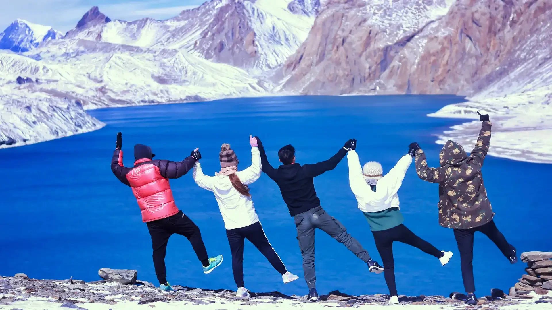
Discover Tilicho lake and its iconic surroundings. Learn all about this lake through the article.
On this page(21)
Tilicho Lake sits at 4,919 meters above sea level in the Manang district of Nepal. That single fact tells you almost everything you need to know about what kind of place this is. It is cold, remote, and demanding to reach. It is also one of the most visually striking places in the entire Himalayan range.
The lake is widely recognized as one of the highest lakes in the world. The water is glacier-fed, a brilliant turquoise color that shifts from deep blue-green to almost teal depending on the light and time of day. The lake stretches approximately 4 kilometers long and 1.2 kilometers wide, with an estimated maximum depth of 85 meters. It is framed on multiple sides by steep rock walls, glaciers, and peaks rising above 7,000 meters.
There are no villages nearby. No shops. No crowds. Just altitude, silence, and a view that makes the effort feel entirely worth it.
This guide covers everything you need to plan a Tilicho Lake trek, including where it is located, how to get there from Kathmandu and Pokhara, what the trail is like, how long it takes, what it costs, when to go, and what to pack.
Where Is Tilicho Lake Located?
Tilicho Lake is located in the Manang district of Gandaki Province in north-central Nepal. It lies within the boundaries of the Annapurna Conservation Area, nestled at the foot of Tilicho Peak, which rises to 7,134 meters.
On a map of Nepal, Tilicho Lake sits northwest of the Annapurna massif, in a high glacial basin above the Marsyangdi River valley. It is accessible primarily via the Annapurna Circuit trail, with a dedicated side route branching off near Manang village toward Khangsar.
The lake sits in a stark glacial cirque. Tilicho Peak (7,134 meters) rises directly to the south. Nilgiri North (7,061 meters) stands to the east. Khangsar Kang forms the northern backdrop. Glaciers hang above the shoreline on multiple sides, creating what many describe as a natural amphitheater.
The Great Barrier, a long ridge separating the Manang Valley from the Mustang region to the north, looms directly above the lake. This dramatic wall of ice and rock is one of the defining visual features of the entire location.
This is not a lake you stumble across. It requires deliberate effort to reach, which is part of why it remains far less crowded than more famous Himalayan destinations.
Tilicho Lake Elevation and Basic Facts
Before getting into the route, it helps to understand the basic numbers:
Tilicho Lake elevation: 4,919 meters (16,138 feet)
Tilicho Peak height: 7,134 meters (23,406 feet)
District: Manang, Gandaki Province
Conservation area: Annapurna Conservation Area (ACAP)
Trek start point: Dharapani, via Besisahar from Kathmandu
Trek end point: Chame (return route) or Muktinath/Jomsom if continuing over Thorong La Pass
Trek duration: 14 days including Kathmandu arrival and departure days
Daily walking: 4 to 7 hours
Total trek distance: approximately 130 to 160 kilometers depending on starting point and whether you cross Thorong La
Distance from Manang to Tilicho Lake and back: roughly 20 kilometers round trip
Difficulty: moderate to challenging
Permits required: ACAP and TIMS card
Is Tilicho Lake the highest lake in the world? Its exact global ranking is debated, as several high-altitude lakes in Tibet exceed its elevation. But Tilicho remains undeniably among the world's highest, and it is the highest lake of its size in the Annapurna region. The elevation alone creates a profound sense of achievement. The setting takes that feeling even further.
The Sacred Significance of Tilicho Lake
Tilicho Lake is not just a geographical landmark. It carries deep spiritual importance for Hindu pilgrims who have journeyed here for centuries, believing the lake corresponds to the mythological Lake Kak Bhushundi mentioned in the Ramayana.
The combination of natural grandeur and spiritual history creates an atmosphere of reverence that many trekkers report feeling regardless of their personal beliefs. Walking the final stretch toward the lake, with the peaks closing in and the air thinning with every step, there is a quality to the silence here that is unlike anything in the lower valleys.
Morning light at Tilicho transforms the experience entirely. The peaks glow pink and gold in the alpenglow while the lake remains in shadow. Then, as the sun rises higher, the light progressively illuminates the water and the turquoise color intensifies. Photographers regularly describe it as one of the most extraordinary subjects they have ever encountered, and equally regularly admit that no photograph captures the scale of it.
Getting to Tilicho Lake: From Kathmandu and Pokhara
Most Tilicho Lake treks begin in either Kathmandu or Pokhara. Both cities offer access to Besisahar, the traditional gateway to the Annapurna Circuit.
From Kathmandu to Tilicho Lake
The distance from Kathmandu to Besisahar is approximately 175 kilometers. By bus, the journey takes around 5 to 7 hours depending on traffic and road conditions. By private jeep, you can reach Besisahar in 4 to 5 hours.
On a standard 14-day itinerary, trekkers depart Kathmandu early on Day 2 and drive first to Besisahar and then continue on rougher road to Dharapani, the trek starting point, arriving late afternoon after a total travel time of 9 to 10 hours. Many trekkers choose to drive as far as Chame or even Manang to cut several walking days off the approach.
From Pokhara to Tilicho Lake
Pokhara to Besisahar takes about 3 to 4 hours by road. From there, the approach is the same as from Kathmandu. Many operators offer Pokhara to Tilicho Lake trek packages that include transport, accommodation, guide, and porter, typically priced between USD 700 and USD 1,100 for 10 to 12 days.
From Jomsom to Tilicho Lake
A less common approach is to arrive from Jomsom in the north. The distance from Jomsom to Tilicho Lake is roughly 30 to 35 kilometers of mountain trail, crossing the Great Barrier from the Mustang side. This route is considerably more challenging than the standard approach from Manang and is suited only to experienced high-altitude trekkers.
The Tilicho Lake Trekking Route
The standard Tilicho Lake trekking route follows the Annapurna Circuit from Besisahar up through the Marsyangdi Valley to Manang, then takes a dedicated side trail northwest to the lake via Khangsar and Tilicho Base Camp. Here is how the route unfolds in six distinct phases.
Phase 1: Marsyangdi Valley Ascent
The trek begins at Dharapani (1,860 meters) and moves through the Marsyangdi River valley, passing pine forests, suspension bridges, and traditional villages including Bagarchhap, Danaque, Timang, Chame, Pisang, Ngawal, and Braga. The steady elevation gain from 1,860 meters to around 3,650 meters over four days allows natural acclimatization.
Views of Annapurna II, Lamjung Himal, and the Manaslu range grow more dramatic with each day. At Chame, the Manang district headquarters, there are hot springs nearby. At Pisang, the trail splits between Upper Pisang, with its traditional gompa and better views, and Lower Pisang on the main trail. At Braga, an ancient gompa built directly into the cliff face is worth a detour before continuing to Manang.
Phase 2: Manang Valley and Acclimatization
Manang village (3,519 meters) is the most important stop on the entire trek. It is large enough to have proper tea houses, bakeries, a small Himalayan Rescue Association facility, and multiple shops.
A full acclimatization day here is not optional. The jump from Manang to Tilicho Lake is 1,400 meters of elevation gain, and attempting it without proper rest dramatically increases the risk of altitude sickness. The HRA runs afternoon lectures on altitude sickness recognition and prevention that are strongly recommended for all trekkers.
Good acclimatization hikes from Manang include:
Gangapurna Lake (3,540 meters), a 45-minute walk beneath the massive Gangapurna glacier
Praken Gompa (3,700 meters), a 1 to 2 hour round trip with excellent valley views
The ridge above the village for views of Annapurna III, Gangapurna, and Tilicho Peak
The principle is climb high, sleep low. Short hikes above your sleeping elevation trigger acclimatization. Do not skip this day.
Phase 3: Approach to Tilicho
From Manang, the trail diverges northwest from the main Annapurna Circuit and crosses the Khangsar Khola river before ascending to Khangsar village (3,750 meters). This small traditional settlement of around 15 to 20 houses maintains strong Tibetan cultural identity. Tea houses here are basic but the mountain views are outstanding, with the Tilicho massif clearly visible.
From Khangsar, the trail continues up through increasingly rocky and barren terrain to Tilicho Base Camp (4,140 meters). Vegetation disappears almost entirely above 4,000 meters. The landscape becomes raw moraine and loose rock. The facilities at base camp are extremely basic: stone shelters with minimal amenities, cold nights, and no guarantee of hot water.
This is also where the famous landslide zone is encountered. The trail traverses a steep, eroded hillside with significant exposure above a long drop. In recent years the path has been improved, but it still demands concentration and sure footing. Trekkers with a fear of heights sometimes find this section uncomfortable. High-quality ankle-supporting trekking boots are essential here. In seasons with higher rockfall risk, some guides recommend a lightweight helmet.
Phase 4: Summit Day to Tilicho Lake
This is the reason you came. Most trekkers wake at 4 to 5 AM at base camp and begin the ascent in darkness or first light. The climb takes 3 to 4 hours, gaining nearly 800 meters on a rocky moraine trail with switchbacks and exposed sections.
The altitude effects are very noticeable above 4,500 meters. Breathe deeply, move slowly, and rest when needed. The final section opens onto the lake plateau.
When the lake appears, the impact is immediate. The turquoise water reflects the surrounding peaks in stillness. Tilicho Peak rises dramatically to the south. The Great Barrier wall stretches across the horizon. If you arrive for sunrise, you watch the first light progressively illuminate the peaks while the lake remains in shadow, then catch the moment the water ignites with color.
Most trekkers spend 1 to 2 hours at the lake. The altitude and wind limit extended stays, but those hours feel timeless. Many people report tears, overwhelming awe, and a profound sense of accomplishment. The Tilicho Lake view point, perched slightly above the eastern shoreline, gives the widest panoramic view of the entire setting.
Descent back to base camp takes 2 to 3 hours on loose rock. Trekking poles are strongly recommended for the descent.
Phase 5: Return Journey
From Tilicho Base Camp, trekkers retrace the route through Khangsar back to Manang. The descent is long but primarily downhill, and bodies are now well acclimatized. Arriving back in Manang feels like luxury after the basic conditions at high camp.
From Manang, the route continues back down the Marsyangdi Valley to Chame, then by road to Kathmandu. The total return drive from Chame to Kathmandu takes 9 to 10 hours.
Phase 6: Continuing to Thorong La Pass
Many trekkers do not return via Manang. Instead, after visiting the lake, they rejoin the main Annapurna Circuit and continue up through Yak Kharka and Thorong Phedi before crossing Thorong La Pass (5,416 meters) to Muktinath. From Jomsom, a scenic flight to Pokhara is the most common way to complete the journey.
This combined Annapurna Circuit trek with Tilicho Lake and Thorong La is widely considered one of the most complete trekking experiences in Nepal.
Tilicho Lake Trek Itinerary: Day by Day
Day 1: Arrival in Kathmandu (1,350 meters). Airport transfer to hotel. Welcome dinner at a traditional Nepali restaurant. Trek briefing with guide covering the itinerary, altitude awareness, gear checks, and permit distribution.
Day 2: Drive from Kathmandu to Besisahar, then continue on rough road to Dharapani (1,860 meters). Total travel time 9 to 10 hours. Overnight tea house in Dharapani.
Day 3: Trek Dharapani to Chame (2,740 meters), 6 to 7 hours. Through pine forests, suspension bridges, and villages along the Marsyangdi River. Views of Annapurna II and the Manaslu range.
Day 4: Trek Chame to Pisang (3,250 meters), 5 to 6 hours. The Annapurna Range dominates the skyline. Upper Pisang has a traditional gompa worth visiting.
Day 5: Trek Pisang to Ngawal (3,650 meters), 6 to 7 hours. Two route options: lower through Hongde and Mungji, or upper through Ghyaru (recommended for better views). Ngawal has an ancient gompa and spectacular Annapurna panoramas.
Day 6: Trek Ngawal to Manang (3,519 meters), 5 to 6 hours. Pass through Braga and its cliff-face gompa. Arrive Manang early afternoon. Attend the HRA altitude sickness lecture.
Day 7: Full acclimatization day in Manang. Hike to Gangapurna Lake or Praken Gompa. Hydrate constantly (3 to 4 liters of water minimum). Rest and eat carb-heavy meals.
Day 8: Trek Manang to Khangsar (3,750 meters), 4 to 5 hours. Diverge from the main Annapurna Circuit. Cross Khangsar Khola river. Arrive at the small traditional village with dramatic Tilicho massif views.
Day 9: Trek Khangsar to Tilicho Base Camp (4,140 meters), 5 to 6 hours. Through rocky moraine and the landslide zone. Vegetation disappears. Basic stone lodges at base camp. Early dinner and early to bed.
Day 10: Pre-dawn ascent to Tilicho Lake (4,919 meters) and return to base camp. 6 to 7 hours total. THE BIG DAY. Early wake-up, steady climb on rocky moraine, 3 to 4 hours to the lake. Spend 1 to 2 hours at the lake. Careful descent 2 to 3 hours back to base camp.
Day 11: Trek Tilicho Base Camp to Manang (3,519 meters) via Khangsar. 6 to 7 hours, primarily downhill. Hot shower, rest, and celebrate.
Day 12: Trek Manang to Chame (2,740 meters), 4 to 5 hours. Familiar trail, warmer temperatures.
Day 13: Drive Chame to Kathmandu, 9 to 10 hours via Besisahar.
Day 14: Final departure from Kathmandu. Transfer to Tribhuvan International Airport based on flight time.
For trekkers continuing over Thorong La, Days 11 onward are replaced with Yak Kharka, Thorong Phedi, the pass crossing to Muktinath, and a flight from Jomsom to Pokhara.
Tilicho Lake Trek Difficulty
The Tilicho Lake trek difficulty is best described as moderate to challenging. There is no technical climbing, no fixed lines, and no glacier travel. But the altitude is serious, the terrain is exposed, and the weather can shift quickly.
The key challenges:
The landslide zone between Khangsar and Tilicho Base Camp is the most physically intimidating section. The trail traverses a steep, eroded hillside. It requires concentration and confident footwork.
The final ascent from base camp to the lake gains nearly 800 meters in 4 to 5 kilometers at very high altitude. Combined with thin air, this section tests even experienced trekkers.
Temperatures at the lake are near or below freezing even during the best trekking seasons. Strong winds are common by early afternoon, which is another reason for an early start.
Altitude sickness is a genuine risk. The jump from Manang to the lake is significant and cannot be rushed. The 14-day itinerary is designed specifically to allow gradual, safe ascent.
That said, this trek is completed successfully by thousands of people each year. If you have done a multi-day high-altitude trek before, you have the baseline experience needed. If this is your first high-altitude trek, go slowly, take every acclimatization day seriously, and hire a guide.
Is the Tilicho Lake Trek Safe for Solo Travelers?
Solo trekking to Tilicho Lake is permitted. No restricted area permit requiring a group minimum applies here, unlike the Manaslu region. But solo trekking carries more risk than going with a guide or group, particularly in the landslide zone and above Tilicho Base Camp.
In the remote stretch between Khangsar and Tilicho Base Camp, there are limited options for assistance if something goes wrong. A guide using a pulse oximeter twice daily to monitor oxygen saturation levels is a meaningful safety measure in this section. Guides are also trained to recognize silent symptoms of altitude sickness, such as sudden loss of appetite or extreme lethargy, before they become emergencies.
If the trail to Tilicho Base Camp is deemed unsafe due to landslide risk or weather, a qualified guide can redirect you to Yak Kharka to continue the Annapurna Circuit without losing the overall trek. Solo trekkers without local knowledge have fewer options in this situation.
Register your itinerary with your embassy, carry a means of emergency communication, and make sure someone knows your plan.
Tilicho Lake Trek in December and Winter
The Tilicho Lake trek in December is possible but demanding. By December, temperatures above 4,000 meters are extreme, and the trail above Tilicho Base Camp can be icy enough to require microspikes or crampons. The landslide zone becomes more hazardous when wet or frozen.
Some tea houses at Tilicho Base Camp close by mid-December. Manang lodges generally remain open through December, but services thin out.
January and February bring the harshest conditions. The trail above 4,000 meters is often blocked by snow. This is not recommended for most trekkers.
For those who do attempt a winter trek, the packing list must account for extreme cold. A four-season sleeping bag, insulated waterproof boots, microspikes, and a full layering system including balaclava and insulated gloves are all essential.
Learn all about the Tilicho lake trek in this guide from Nepal Visuals.
Tilicho Lake Weather
Tilicho Lake weather is harsh by most standards, even in ideal conditions. The lake's position in a high glacial basin makes temperatures more extreme than the valleys below.
In spring and autumn, daytime temperatures at the lake range from around 0 to 8 degrees Celsius. Nights drop well below freezing. Strong winds are common by early afternoon. In winter, temperatures at the lake can reach minus 15 to 20 degrees Celsius on cold nights.
One practical note on technology: cold temperatures at this altitude drain batteries approximately 30 percent faster than normal. Carry a 20,000 mAh power bank and keep your phone and spare batteries inside your sleeping bag at night to prevent them from losing charge in the cold.
Charging at tea houses above base camp relies on solar power and costs USD 3 to 6 per device. Plan your electronics use accordingly.
Best Time to Visit Tilicho Lake
Spring (March to May) is one of the two prime trekking seasons. Rhododendrons bloom in the lower valleys, temperatures are warming, and skies are generally clear. Note that in early March, the lake itself may still be completely frozen and covered in deep snow, resembling a vast white plain rather than the famous turquoise water. For the vibrant lake color, aim for April or May.
Autumn (late September to November) is the single best season for the Tilicho Lake trek. Skies are crystal clear after the monsoon, mountain views are at their sharpest, and trail conditions are excellent. October is the standout month for a combination of weather, visibility, and color. The lake is in its liquid turquoise form and the surrounding peaks are fully visible.
Winter (December to February) is for experienced cold-weather trekkers only. Expect icy trails, extreme temperatures, and possible closures of high-altitude tea houses.
Monsoon (June to August) is not recommended. Heavy rainfall makes trails slippery and increases landslide risk, particularly in the zone above Khangsar. Visibility is poor and leeches are active in the lower forests.
Permits Required for the Tilicho Lake Trek
Two permits are required for the Tilicho Lake trek. Importantly, as of 2026, no restricted area permit is required for this route, making the paperwork considerably simpler than many other remote Himalayan destinations.
Annapurna Conservation Area Permit (ACAP)
This is the primary permit for all trekking in the Annapurna Conservation Area. The entry fee for foreign nationals is NPR 3,000 per person, roughly USD 22 to 25.
TIMS Card (Trekkers Information Management System)
The TIMS card costs approximately USD 20 for independent trekkers and provides a registration system that helps authorities locate trekkers in remote areas.
Both permits can be obtained in Kathmandu at the Nepal Tourism Board office or in Pokhara at the TAAN office. They cannot be obtained on the trail. Bring two passport-sized photos and a copy of your passport and visa when applying.
Tilicho Lake Trek Cost
The total cost of the Tilicho Lake trek depends on how you organize it and what is included.
Independent trekking costs:
ACAP and TIMS permits: approximately USD 40 combined
Tea house accommodation: USD 5 to 15 per night depending on elevation
Meals: USD 15 to 30 per day, rising at higher altitudes
Hot showers, Wi-Fi, device charging: paid separately at most tea houses
Transport from Kathmandu or Pokhara to the trailhead: USD 15 to 40 depending on vehicle
Guided package costs:
Tilicho Lake trek packages through registered Nepali trekking agencies typically cost between USD 850 and USD 1,300 for 14 days. Standard inclusions in organized packages are:
Airport pickup and drop-off, all land transport in a private tourist vehicle
All necessary permits and conservation fees
Government-certified, English-speaking guide
Porter service (typically one porter per two trekkers, with a 10 kilogram limit per person)
Twice-daily health monitoring using a pulse oximeter
Full board meals throughout the trek
Tea house accommodation on twin-sharing basis
Kathmandu hotel accommodation on arrival and departure
Welcome dinner in Kathmandu
Emergency coordination support
Trek completion certificate
Standard exclusions include international flights, Nepal entry visa (USD 50 for 30 days), travel and medical insurance, personal trekking gear, alcoholic and bottled drinks, hot showers and device charging on the trail, and tips for guides and porters.
Guide and porter rates:
Licensed guide: USD 25 to 35 per day
Porter: USD 15 to 22 per day
Tipping is customary. A standard tip at the end of the trek is one to two days of their daily rate.
Accommodation on the Tilicho Lake Trek
Tea houses are the primary accommodation along the entire route. Standards vary considerably by elevation.
In Chame and Manang, tea houses are relatively comfortable with private rooms, attached bathrooms in some lodges, and reasonably diverse food menus. Wi-Fi is available in Manang, though slow. Manang's bakeries are well-known among trekkers, particularly for apple pie.
Above Manang, facilities become more basic. Khangsar and Tilicho Base Camp have a small number of simple lodges. Expect shared facilities, very cold nights, and limited food options. There is no accommodation at Tilicho Lake itself. The lake is always a day-trip destination from base camp.
On nutrition: above 3,500 meters, dal bhat (lentils, rice, and vegetable curry) is the most reliable and recommended meal. It provides steady energy release, is freshly prepared in every lodge, and is easier to digest at altitude than meat-heavy meals. Avoiding alcohol above 3,500 meters is also strongly recommended for maintaining oxygen levels during the most demanding days.
Connectivity at Tilicho Lake
In late 2023, internet connectivity was established at Tilicho Lake (4,919 meters) primarily to aid in emergency communications and safety. While it should not be relied upon for streaming or regular use, it does allow trekkers to check weather updates or contact family before descending. This is a significant development for safety in one of the most remote overnight spots in the Annapurna region.
Below the lake, cell coverage is limited above Manang. Plan your communications accordingly and carry an emergency contact plan.
Packing List for the Tilicho Lake Trek
The Tilicho Lake trek packing list must account for conditions ranging from warm subtropical valleys to freezing temperatures above 4,900 meters.
Essential items:
Down jacket insulated to at least minus 10 degrees Celsius
Waterproof shell jacket and pants
Merino wool or synthetic base layers (two sets minimum)
Mid-layer fleece or softshell
Warm hat, balaclava, and sun hat
Insulated waterproof gloves
Trekking boots with solid ankle support and waterproofing
Microspikes for icy sections in late autumn or early spring
Lightweight helmet (recommended by guides during higher rockfall risk seasons)
Trekking poles (essential for the descent from the lake)
Headlamp with spare batteries
Sunglasses rated UV400 or higher
Sunscreen SPF 50 or higher
Two 1-liter reusable bottles (single-use plastics are banned in the Annapurna region)
Water purification tablets or UV filter
20,000 mAh power bank
Rehydration salts
Basic first aid kit
Diamox (acetazolamide) if prescribed by your doctor
Hydration note: drink a minimum of 4 liters of water per day at high altitude. Many lodges offer safe drinking water stations where you can refill for a small fee. This is your best defense against altitude-related headaches.
Physical Fitness for the Tilicho Lake Trek
You do not need to be an elite athlete, but a solid aerobic fitness base is essential. The combination of consecutive high-altitude days and significant elevation gain will test your cardiovascular system regardless of how fit you are at sea level.
Recommended preparation in the two to three months before your trek:
Cardiovascular training: hiking, running, cycling, or stair climbing for at least 45 minutes, four to five times per week
Leg strength: squats, lunges, and step-ups for the demands of steep descents
Loaded pack hikes on inclines as close to realistic trail conditions as possible
If you plan to continue over Thorong La Pass (5,416 meters) after visiting the lake, your training should account for back-to-back demanding high-altitude days.
This trek is ideal for experienced trekkers who have completed multi-day routes like Everest Base Camp or the Annapurna Base Camp trek. It is not recommended as a first-ever high-altitude experience.
Cultural Highlights Along the Route
The Tilicho Lake trek passes through a fascinating cultural transition, moving from the Hindu-influenced lowlands near Besisahar to the Tibetan Buddhist highlands of Manang. By the time trekkers cross toward Muktinath, if continuing the circuit, they encounter a unique fusion of both religious traditions that is not easily found anywhere else in Nepal.
Villages along the route each have distinct character:
Dharapani marks the cultural gateway from the lower hills to the Buddhist highlands
Chame is the administrative district headquarters with a more developed feel
Pisang, particularly Upper Pisang, maintains a traditional gompa and layout unchanged for generations
Ngawal has an ancient monastery with outstanding Annapurna views
Manang is the cultural and commercial hub of the upper valley
Khangsar is one of the most authentic remaining mountain villages on the route, small and largely unchanged by tourism
When visiting monasteries, always walk clockwise around mani walls and chortens. Remove shoes and hats before entering any prayer hall. Leave a small donation in the monastery collection box.
Wanna go for the Annapurna Circuit Trek where the Tilicho lake is located?
Frequently Asked Questions
What makes Tilicho Lake special compared to other Himalayan lakes?
Sitting at 4,919 meters in a dramatic glacial cirque backed by the Great Barrier wall of ice, Tilicho offers a far more extreme alpine setting than most accessible lakes. The combination of its elevation, the surrounding peaks, its spiritual significance, and its relative remoteness sets it apart.
Is the trail to Tilicho Lake dangerous?
The section between Khangsar and Tilicho Base Camp involves crossing steep scree slopes in the landslide zone. It requires focus and a steady foot but is not technically dangerous in normal conditions. Guides assess conditions before leading groups through. If the path is deemed unsafe, the standard contingency is to redirect to Yak Kharka and continue the Annapurna Circuit.
What is the best time to see the lake as turquoise water rather than frozen?
October and November are best for vivid turquoise water. In early spring, particularly March and early April, the lake is often completely frozen and covered in deep snow.
Does the 14-day trek also include Thorong La Pass?
Some versions of the 14-day itinerary do include Thorong La Pass (5,416 meters), making it a complete Annapurna Circuit. On these itineraries, after visiting the lake you rejoin the main circuit and cross the pass to Muktinath. This makes the highest point of the trek 5,416 meters, not the lake itself.
What permits are required?
The ACAP and TIMS card are the two required permits. As of 2026, no restricted area permit is required for the Tilicho route. Both permits must be obtained before the trek begins.
What is accommodation like at Tilicho Base Camp?
Lodges at Tilicho Base Camp (4,140 meters) are very basic and can be crowded during peak season. Expect shared facilities, very cold nights, and minimal amenities. Come prepared.
Do I need crampons?
Microspikes are highly recommended if trekking in late autumn or early spring. The descent from the lake and sections of the Thorong La Pass crossing can be icy and slippery.
How is altitude sickness managed?
The 14-day itinerary includes a mandatory acclimatization day in Manang at 3,519 meters. Guided treks include twice-daily pulse oximeter readings above base camp. Follow the climb high, sleep low principle and never ascend if you feel significantly unwell.
Will I have internet access at the lake?
Limited connectivity exists at Tilicho Lake as of late 2023, primarily for safety and emergency communication. Do not rely on it for regular use, but it is available for weather checks and contacting family before descending.
Why Tilicho Lake Is Worth the Effort
There is a straightforward reason why Tilicho Lake keeps appearing on serious trekkers' lists. It delivers something genuinely rare: a high-altitude destination that is both physically meaningful to reach and visually extraordinary when you get there.
The trek combines subtropical forest, alpine moraine, ancient monasteries, dramatic passes, and one of the highest lakes on the planet, all within a single coherent route. The 14-day itinerary is structured specifically to allow your body to adapt safely and arrive at the lake in a condition to actually enjoy it, rather than simply survive it.
The Annapurna Circuit trek with Tilicho Lake included is among the most complete trekking experiences available in Nepal. For those willing to invest the time and preparation, it is one of the most rewarding.
Contact us at Nepal Visuals for booking and inquires related to Tilicho Lake and other popular treks in Nepal.
Tilicho Lake altitude, Manang and how to get there
Tilicho Lake lies at 4,919 m (16,138 ft) beneath the Great Barrier in the Manang district of Nepal, which places it among the highest lakes in the world. The approach begins from Manang village at roughly 3,540 m (11,614 ft), then climbs through Khangsar and Siri Kharka to Tilicho Base Camp before the final ascent to the shoreline.
Most trekkers combine the lake with the Annapurna Circuit and cross Thorong La at 5,416 m (17,769 ft) afterwards. October and November show the water at its clearest turquoise; in early spring it is often frozen. If you want to walk it with a guide, see the 14-day Tilicho Lake Trek or the 14-day Annapurna Circuit Trek.
Sharing route guides and trail experience from the high trails of Nepal.