 Nepal Visuals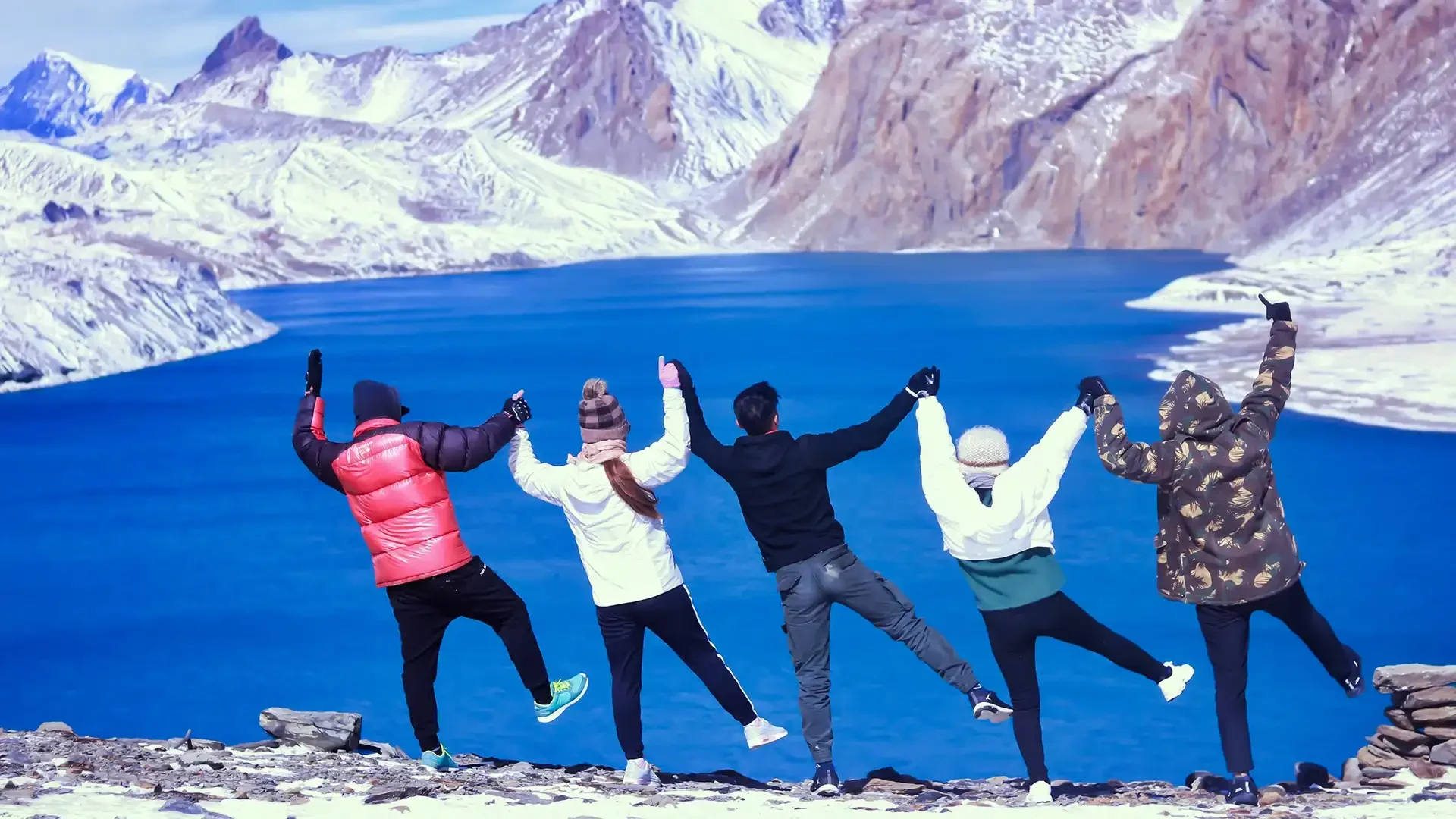
Annapurna Region · Moderate grade
Tilicho Lake Trek
The route
What the walk is.
The Tilicho Lake Trek (14 Days) is a spectacular high-altitude adventure that takes trekkers to one of the world’s highest lakes, Tilicho Lake (4,919 m), set in a dramatic glacial basin surrounded by towering Annapurna peaks. This journey is perfect for experienced trekkers seeking a remote and challenging Himalayan experience combined with breathtaking scenery, cultural immersion, and proper acclimatization for safe high-altitude trekking.
The trek begins along the classic Annapurna Circuit trail through Marsyangdi Valley, passing Dharapani, Chame, and Pisang with lush forests, terraced fields, and charming villages. A crucial acclimatization day in Manang (3,519 m) ensures trekkers adjust to the altitude while exploring Tibetan-Buddhist culture and local traditions.
From Manang, the route diverges northwest through traditional Khangsar village toward Tilicho Base Camp (4,140 m). The trail gradually climbs into alpine terrain, offering panoramic views of Annapurna II, III, IV, Gangapurna, Tilicho Peak, and Nilgiri. Each step brings you closer to the ultimate reward: the turquoise waters of Tilicho Lake reflecting the surrounding peaks in pristine serenity.
The trek is moderate to challenging, with daily walking distances of 4–7 hours, and requires good fitness and previous multi-day trekking experience. Unlike the heavily trafficked Thorong La Pass, Tilicho Lake offers a quieter, more intimate high-altitude experience, making it ideal for photographers, spiritual seekers, and adventurers looking for off-the-beaten-path exploration.
This 14-day adventure combines remote alpine landscapes, cultural richness, and a profound sense of accomplishment, delivering a truly unforgettable Himalayan experience. Best undertaken in spring (March–May) or autumn (September–November) for stable weather and crystal-clear mountain views.
General Information
Detail | Information |
Start Point | Dharapani (via Besisahar from Kathmandu) |
End Point | Chame (return to Kathmandu) |
Daily Walking | 4-7 hours |
Rest Days | 1 acclimatization day (Manang) |
Kathmandu Days | 2 days (arrival, departure) |
Permits Required | ACAP, TIMS |
Ideal For | High-altitude enthusiasts, experienced trekkers |
What makes Tilicho Lake extraordinary:
World's Highest Lake Status: At 4,919 meters, Tilicho ranks among the world's highest lakes (exact ranking debated but undeniably in top tier). The elevation alone creates profound sense of achievement, but the setting elevates this beyond statistics: brilliant turquoise waters surrounded by 7,000m+ peaks, glaciers cascading down mountainsides, complete silence broken only by wind and occasional ice crack.
Sacred Significance: Hindu pilgrims have journeyed to Tilicho for centuries, believing it corresponds to mythological Lake Kak Bhushundi mentioned in the Ramayana. The combination of natural beauty and spiritual importance creates atmosphere of reverence many trekkers report feeling regardless of personal beliefs.
Dramatic Setting: The lake sits in stark glacial cirque with Tilicho Peak (7,134m) rising directly south, Nilgiri North (7,061m) east, and other 6,000-7,000m peaks surrounding. Morning light transforms the turquoise waters while mountains glow pink and gold in alpenglow—photographers' paradise.
Proper Acclimatization: Unlike rushed itineraries risking altitude sickness, this 14-day schedule provides gradual ascent: steady climb from Dharapani (1,860m) through Chame (2,740m), Pisang (3,250m) to Manang (3,519m) over 4 days, crucial rest day at Manang, then careful 3-day progression to Tilicho Lake (4,919m). This pacing dramatically increases success rate and safety.
The complete package handles everything: Kathmandu arrival with welcome dinner and trek briefing, scenic drive to trek starting point, experienced guide specializing in high-altitude trekking, porter service, comfortable teahouse accommodation (basic at high altitudes but adequate), all meals during trek, permits, emergency support, and return transportation to Kathmandu. Focus on the adventure while we manage logistics.
Why choose Nepal Visuals for the 14-day Tilicho Lake Trek?
Reaching the world's highest lake takes serious preparation
At 4,919 m, Tilicho Lake demands careful acclimatization planning. Our itinerary builds altitude gradually across 14 days so your body arrives at the lake edge strong and fully adjusted.
Daily health checks on a high and remote trail
The approach to Tilicho passes through isolated terrain far from evacuation routes. Our guides monitor your oxygen levels and physical condition every day so risks are identified and managed early.
A route few trekkers take, guided by those who know it well
Tilicho remains one of Nepal's least crowded high-altitude destinations. Our guides have navigated its exposed ridges and steep lake approach repeatedly and bring that experience to every group they lead.
Every detail confirmed well before your flight lands
ACAP and TIMS permits, teahouse bookings through Chame, Pisang, and Manang, and all ground transfers are arranged ahead of your arrival so the trek begins the moment you step off the plane.
Full cost laid out clearly from the start
Remote treks can carry unexpected expenses. Ours do not. Every permit, accommodation, and guide fee is included in your quoted price so there is nothing to reconcile at the end of 14 days.
Preparation advice built around Tilicho's specific demands
The trail's high exposure, variable weather, and long summit-day push require targeted training and packing guidance. We send a route-specific plan to every trekker after booking is confirmed.
Manang valley culture given the time it deserves
The Tibetan-influenced communities of the upper Manang valley are among the most distinct in Nepal. Our itinerary preserves unhurried time in these villages rather than treating them as overnight stops.
City luggage stays safe while you take on the high trail
Store non-essential bags at our secure Kathmandu facility at no charge throughout your 14 days, and walk back through the door to find everything exactly as you left it.
Reachable support on one of Nepal's more demanding routes
The remoteness of the Tilicho trail makes reliable communication with your support team more important, not less. We stay available via WhatsApp, Email, and Zoom throughout the full journey.
Your Tilicho Lake day is protected from the moment you book
We guarantee every confirmed departure runs as planned regardless of group size. Fourteen days of anticipation for one of Nepal's most extraordinary lake views will never end in a cancellation from our side.
Tilicho Lake and Manang: altitude and route facts
Tilicho Lake sits at 4,919 m (16,138 ft), which makes it one of the highest lakes in the world and the reason this route is treated as a serious high-altitude trek rather than a side trip. The approach runs through Manang, the main village of the upper Marsyangdi valley at roughly 3,540 m (11,614 ft), where the itinerary builds in acclimatisation before you climb to Tilicho Base Camp and on to the lake itself.
After the lake you rejoin the classic Annapurna Circuit and cross Thorong La at 5,416 m (17,769 ft), the highest point of the whole trek. October and November give the clearest turquoise water; in March and April the lake is often still frozen and snow-covered. For background on the lake itself, read our Tilicho Lake guide.
Day by day
Where you sleep, night by night.
Kathmandu → Kathmandu · highest point 4,919 m
- Day 01Hotel (Twin Sharing) · Welcome Dinner1,400 m
Your Nepal Visuals representative meets you at the airport and transfers you to your hotel. Welcome briefing and dinner.
- Day 02Tea House (Twin Sharing) · Breakfast, Lunch, Dinner840 m
Drive to Besisahar (6 hours) then begin trekking through subtropical farmland along the Marsyangdi River. First steps of the Annapurna Circuit trail.
- Day 03Tea House (Twin Sharing) · Breakfast, Lunch, Dinner2,710 m
Follow the Marsyangdi upstream through the narrowing gorge crossing suspension bridges. Pass through ethnic villages as the landscape transforms from subtropical to temperate. Arrive at Chame, district headquarters.
- Day 04Tea House (Twin Sharing) · Breakfast, Lunch, Dinner3,200 m
Continue ascending through forests with stunning Annapurna II views. The valley dramatically opens at Pisang. Explore Upper Pisang with its ancient gompa perched high above the village.
- Day 05Tea House (Twin Sharing) · Breakfast, Lunch, Dinner3,650 m
Take the upper route via Ghyaru for spectacular Annapurna panoramas. Arrive Ngawal, a traditional village with ancient gompa and dramatic mountain views. Afternoon rest and acclimatisation walks.
- Day 06Tea House (Twin Sharing) · Breakfast, Lunch, Dinner3,519 m
Pass through Braga village with its cliff-face gompa. Arrive Manang for the essential acclimatisation stop. Attend the HRA altitude lecture this afternoon.
- Day 07Rest day · Tea House (Twin Sharing) · Breakfast, Lunch, Dinner3,519 m
Crucial rest day. Hike to Gangapurna Lake or Praken Gompa. Hydrate constantly. This day is essential before the high passes ahead.
- Day 08Tea House (Twin Sharing) · Breakfast, Lunch, Dinner3,750 m
Leave the main Annapurna Circuit and branch west toward Tilicho Lake. Trek to Khangsar village, the last permanent settlement before the lake. Arrive early for rest and acclimatisation.
- Day 09Tea House (Twin Sharing) · Breakfast, Lunch, Dinner4,150 m
Ascend through dramatic moraines and high alpine terrain to Tilicho Base Camp. The trail traverses an exposed cliff section and crosses glacial streams. Stunning views of the surrounding peaks. Rest well tonight for tomorrow early start.
- Day 10Highest point · Tea House (Twin Sharing) · Breakfast, Lunch, Dinner4,919 m
The highlight of the trek. Ascend to Tilicho Lake, one of the highest lakes in the world at 4,919m. The lake is ringed by glaciers and towering peaks and turns a magnificent deep blue in clear weather. Return to Khangsar by afternoon.
- Day 11Tea House (Twin Sharing) · Breakfast, Lunch, Dinner2,720 m
Return trek descending through the Kali Gandaki valley. Option to cross the Mesokanto Pass (5,100m) for a more adventurous return. Arrive in Jomsom, the Mustang gateway town.
- Day 12Hotel (Twin Sharing) · Breakfast, Lunch, Dinner822 m
Morning flight from Jomsom to Pokhara with panoramic Annapurna and Dhaulagiri views. Afternoon free at Phewa Lake to rest and celebrate.
- Day 13Hotel (Twin Sharing) · Breakfast, Dinner1,400 m
Scenic drive back to Kathmandu along the Prithvi Highway. Arrive afternoon for a farewell dinner in Thamel.
- Day 14Breakfast1,400 m
Transfer to Tribhuvan International Airport for your onward flight. You have stood at one of the highest lakes on Earth.
Fixed departures
12 group dates open.
144 places across them. Or start on any flexible date in the calendar below.
| Departure | Booked | Filling | Left | Status | Book |
|---|---|---|---|---|---|
| Sat, Mar 6, 2027 | 0/12 | 12 | Available | ||
| Sat, Mar 20, 2027 | 0/12 | 12 | Available | ||
| Sat, Apr 3, 2027 | 0/12 | 12 | Available | ||
| Sat, Apr 17, 2027 | 0/12 | 12 | Available | ||
| Sat, May 1, 2027 | 0/12 | 12 | Available | ||
| Sat, May 15, 2027 | 0/12 | 12 | Available | ||
| Sat, Sep 4, 2027 | 0/12 | 12 | Available | ||
| Sat, Sep 18, 2027 | 0/12 | 12 | Available | ||
| Sat, Oct 2, 2027 | 0/12 | 12 | Available | ||
| Sat, Oct 16, 2027 | 0/12 | 12 | Available | ||
| Sat, Nov 6, 2027 | 0/12 | 12 | Available | ||
| Sat, Nov 20, 2027 | 0/12 | 12 | Available |
Prices are per person, twin share, in USD. Book with a 20 % deposit — the balance is due 7 days before departure. Scheduled departures show places left; flexible departures can be booked on any listed start date. Booking terms
| Su | Mo | Tu | We | Th | Fr | Sa |
|---|---|---|---|---|---|---|
| 1 | 2 | 3 | ||||
| 4 | 5 | 6 | 7 | 8 | 9 | 10 |
| 11 | 12 | 13 | 14 | 15 | 16 | 17 |
| 18 | 19 | 20 | 21 | 22 | 23 | 24 |
| 25 | 26 | 28 | 29 | 30 |
- Selected trip dates
- Available
- Filling fast
- Almost sold out
- Sold out
Tue, Oct 27Mon, Nov 9, 2026
14 days · flexible departure
- StartsTue, Oct 27, 2026 · Kathmandu
- EndsMon, Nov 9, 2026 · Kathmandu
USD $850 per person, twin share · Deposit today USD $170 (20 %)
On the trail
Photographs from the route.
Moderate grade
Is this trek right for you?
You can do this if…
- ✓Walk 5–6 hours a day, some of it steep
- ✓Carry a 5–8 kg daypack
- ✓Comfortable with several days in a row on foot
Recommended preparation
- ✓2–3 months of regular cardio (walking, running, cycling)
- ✓Weekend hikes with a loaded pack
- ✓Read the altitude notes below — you will sleep above 3,000 m
Experience & support
- ✓A good first Himalayan trek
- ✓Guided throughout — a licensed guide is required on Nepal treks
- ✓Unsure about age, health or fitness? Ask us — we tailor the pace
About three months out? Follow our free 12-week trek fitness plan.
Good to know
Additional information.
Journey to Tilicho: The Route
Phase 1 - Marsyangdi Valley Ascent (Days 2-6): Drive from Kathmandu to Besisahar then Dharapani (1,860m). Trek through beautiful Marsyangdi River valley passing pine forests, suspension bridges, traditional villages. Steady elevation gain from 1,860m to 3,650m (Ngawal) over 4 days allows natural acclimatization. Views of Annapurna II, Lamjung Himal, Manaslu range appearing and growing more dramatic daily.
Phase 2 - Manang Valley & Acclimatization (Days 6-7): Reach Manang (3,519m), beautiful village and trek's acclimatization hub. Full rest day exploring surrounding area: optional hikes to Gangapurna Lake, Praken Gompa monastery, viewpoints, or simply resting and hydrating. This rest day crucial for safe progression to higher altitudes.
Phase 3 - Approach to Tilicho (Days 8-9): Diverge from main Annapurna Circuit route, trek northwest through increasingly dramatic landscape to Khangsar village (3,750m), traditional settlement maintaining Tibetan culture. Continue to Tilicho Base Camp (4,140m), basic facilities but spectacular mountain views. Terrain becomes progressively more barren and rocky as vegetation disappears above 4,000m.
Phase 4 - Summit Day (Day 10): Pre-dawn start from Base Camp (optional for sunrise at lake, though mid-morning also beautiful). Steady climb on rocky moraine trail to Tilicho Lake (4,919m), approximately 3-4 hours. Reach the stunning turquoise lake surrounded by massive peaks. Time for photos, contemplation, snacks, celebrating achievement. Return to Base Camp (2-3 hours downhill). Total 6-7 hours.
Phase 5 - Return Journey (Days 11-12): Retrace route to Manang, descend to Chame. Faster descent as bodies acclimatized, though still careful pacing. Opportunity to revisit favorite spots, purchase handicrafts forgotten earlier, enjoy familiar teahouses.
Phase 6 - Return to Kathmandu (Day 13): Drive from Chame through Besisahar to Kathmandu (9-10 hours), scenic journey allowing reflection on incredible journey.
Tilicho Lake: The Sacred Destination
Standing at 4,919 meters surrounded by towering peaks with brilliant turquoise lake before you creates moments that transcend typical trekking experiences. Many trekkers report profound emotional responses—tears, laughter, overwhelming awe at nature's grandeur and their own accomplishment reaching this remote, spectacular place.
Lake Characteristics: Approximately 4 km long, 1.2 km wide, maximum depth estimated 85 meters. The distinctive turquoise color comes from glacial flour (finely ground rock particles suspended in water) reflecting sunlight. Depending on season, weather, and time of day, colors shift from deep blue-green to brilliant turquoise to almost teal.
Surrounding Peaks: Tilicho Peak (7,134m) rises dramatically south of lake creating stunning backdrop. Nilgiri range east, Khangsar Kang north, other 6,000-7,000m peaks surrounding creating natural amphitheater. Morning alpenglow transforms peaks in pink and gold while lake remains in shadow, then sunlight progressively illuminates water creating magical color transitions.
Weather & Conditions: Even during good seasons (spring/autumn), Tilicho Lake area experiences harsh conditions: strong winds common, temperatures near or below freezing, weather can change rapidly from clear to snow/clouds. Come prepared for extreme conditions even if forecast looks good. The harsh environment adds to the achievement—this isn't casual nature stroll but genuine high-altitude adventure.
Time at Lake: Most trekkers spend 1-2 hours at the lake before returning to Base Camp (same-day round trip standard). The altitude and cold limit extended stays, but the hours there feel timeless. Photography, contemplation, sharing the moment with fellow trekkers who've made the same journey, simple eating of snacks while surrounded by mountain vastness.
Manang: The Acclimatization Hub
Manang village (3,519m) serves as this trek's crucial acclimatization stop and cultural highlight. This large, beautiful settlement in the Manang Valley features traditional Tibetan-style architecture, active monasteries, stunning mountain views (Gangapurna's massive face looms directly north), and comprehensive trekking infrastructure developed over decades of Annapurna Circuit traffic.
Acclimatization Day Activities:
Hike to Gangapurna Lake (45 minutes) beneath Gangapurna glacier
Visit Praken Gompa monastery above village (views reward climb)
Himalayan Rescue Association lecture on altitude sickness (highly recommended)
Simply rest, hydrate, read, journal at comfortable teahouse
Explore village visiting shops, bakeries (famous for apple pie), cultural sites
Why Manang Matters: The full rest day at 3,519m allows bodies to adjust before pushing to 4,919m at Tilicho Lake. This "climb high, sleep low" principle (short hikes above village elevation then return) triggers acclimatization. Rushing through Manang dramatically increases altitude sickness risk at Tilicho.
Cultural Richness: Tibetan Buddhist Heritage
Upper Annapurna region maintains strong Tibetan cultural identity. Most residents practice Tibetan Buddhism, speak Tibetan dialects alongside Nepali, maintain traditional architecture and customs. Villages feature stupas, prayer wheels, mani walls, monasteries—spiritual infrastructure reflecting deep religious commitment.
Villages En Route:
Dharapani: Gateway village, cultural transition from Hindu lowlands to Buddhist highlands
Chame: Manang district headquarters, administrative center, traditional homes
Pisang: Split between Upper Pisang (traditional) and Lower Pisang (more developed)
Ngawal: Beautiful village with ancient gompa, traditional lifestyle maintained
Manang: Cultural and commercial hub, modernized but retaining character
Khangsar: Small traditional village near Tilicho, authentic mountain life
Who Should Trek to Tilicho Lake
Ideal for:
Experienced trekkers seeking high-altitude challenge without technical climbing
Adventure photographers wanting unique lake and mountain compositions
Spiritual seekers drawn to sacred sites and profound natural settings
Those who've done ABC/Poonhill seeking more remote, challenging experience
Trekkers specifically wanting "world's highest lake" achievement
Anyone comfortable with basic facilities and remote conditions
Those with 2 weeks available for proper acclimatization and pacing
Not ideal for:
Complete beginners (the 4,919m altitude too challenging for first trek)
Those uncomfortable with basic high-altitude facilities
Anyone with altitude sensitivity or health issues
Trekkers requiring daily showers, WiFi, comfort (very basic at Tilicho Base Camp)
Those uncomfortable with significant altitude challenge
Before you book
Questions we get most.
The Lake & Surroundings
What makes Tilicho Lake so special compared to other Himalayan lakes?
Sitting at 4,919m, Tilicho is one of the highest lakes in the world. It is a massive turquoise jewel backed by the "Great Barrier" wall of ice, offering a much more dramatic alpine setting than lower-altitude lakes.
Is the trail to Tilicho Lake considered dangerous?
The section between Siri Kharka and Tilicho Base Camp involves crossing steep scree slopes known as "landslide zones." While it requires focus and a steady foot, our guides ensure you pass through safely when conditions are optimal.
What is the best time to see the lake in its liquid form?
To see the vibrant turquoise water, October and November are best. In early spring (March-April), the lake is often completely frozen and covered in deep snow, resembling a vast white plain.
Difficulty & Thorong La
Does this 14-day trek also cross the Thorong La Pass?
Yes, after visiting the lake, you rejoin the main Annapurna Circuit to cross Thorong La (5,416m). This makes the 14-day version a complete adventure that covers both the highest lake and the highest pass in the region.
How difficult is this trek compared to the standard Annapurna Circuit?
It is more strenuous because you spend several extra days above 4,000m. However, the time spent at Tilicho Lake acts as excellent acclimatization, often making the final pass crossing feel easier than for those who skip the lake.
What is the highest point I will reach on this trek?
While Tilicho Lake is 4,919m, your highest point is actually the Thorong La Pass at 5,416m, which you will reach a few days after visiting the lake.
Logistics & Permits
What permits are required for the Tilicho Lake route?
You need the ACAP (Annapurna Conservation Area Permit) and a TIMS card. As of 2026, special "restricted area" permits are not required for Tilicho, making it accessible with standard trekking documentation.
What is the accommodation like at Tilicho Base Camp?
Lodges at Tilicho Base Camp (4,150m) are very basic and often crowded. We recommend being prepared for shared facilities and very cold nights, as this is one of the most remote overnight spots on the trek.
How do we return to Kathmandu after 14 days?
After crossing the pass to Muktinath and Jomsom, we typically take a scenic flight to Pokhara and then a tourist bus or flight back to Kathmandu to conclude the journey.
Health & Gear
Do I need crampons for the Tilicho Lake trail?
If you are trekking in late autumn or early spring, micro-spikes are highly recommended. The steep descent from the lake and the Thorong La Pass can be very icy and slippery.
How do we manage the risk of altitude sickness?
Our 14-day itinerary includes a mandatory acclimatization day in Manang (3,540m). This allows your body to produce necessary red blood cells before you push toward the lake and the high pass.
What should I pack specifically for the landslide zones?
High-quality, ankle-supporting trekking boots are essential for stability on the loose scree. Additionally, a lightweight helmet is sometimes recommended by guides in specific seasons when rockfall risk is higher.
Advanced Acclimatization & Safety
What is the "Climb High, Sleep Low" strategy for Tilicho?
While you have an acclimatization day in Manang (3,540m), the real work happens on the trek to Siri Kharka. We use the day to hike toward the Gangapurna Ice Lake or a nearby ridge, reaching roughly 4,000m before descending to sleep. This "staged" approach is critical because it prepares your lungs for the massive jump to the 4,919m lake just 48 hours later.
How do guides manage health in the high-altitude "blackout" zones?
In the remote stretch between Siri Kharka and Tilicho Base Camp, your guide will use a pulse oximeter twice daily to track your oxygen saturation. Because this section is isolated, we monitor for "silent" symptoms of altitude sickness—like sudden loss of appetite or extreme lethargy—ensuring you don't push toward the lake if your body is struggling to adapt.
Is there an emergency "Plan B" if the Tilicho trail is blocked?
As of 2026, the trail to the lake is well-maintained, but landslide risk can fluctuate with weather. If the path to Tilicho Base Camp is deemed unsafe by our scouts, your itinerary pivot is seamless. We move directly to Yak Kharka to continue the Annapurna Circuit, ensuring you still complete the 5,416m Thorong La Pass without wasting precious trekking days.
Connectivity & Modern Amenities
Will I have internet access at one of the world's highest lakes?
Surprisingly, yes. In late 2023, internet connectivity was established at Tilicho Lake (4,919m) to aid in emergency communications and safety. While you shouldn't rely on it for streaming, it is a game-changer for safety, allowing trekkers to check weather updates or contact family before heading back down to the Base Camp.
How do I handle the "Charging Challenge" on a 14-day trip?
Teahouses at Tilicho Base Camp and Thorong Phedi rely heavily on solar power and charge a premium ($3–$6) per device. Because cold temperatures drain batteries 30% faster at these altitudes, we recommend a 20,000mAh power bank. Keep your phone and spare batteries inside your sleeping bag at night to prevent the freezing mountain air from killing your charge.
Nutrition & Mountain Wellness
What is the best "Summit Fuel" for the lake and the pass?
We strictly recommend the "Dal Bhat" power—a traditional meal of lentils, rice, and vegetable curry. It is the only meal that provides a constant release of energy and is freshly prepared in every lodge. Avoiding meat and alcohol once you move above 3,500m is also essential to keep your digestion smooth and your oxygen levels high during the most strenuous days.
How do I stay hydrated without using plastic bottles?
The Annapurna region has a strict single-use plastic ban. You must carry two 1-liter reusable bottles and use water purification tablets or a UV filter. Many lodges also offer "Safe Drinking Water" stations where you can refill for a small fee. Drinking 4 liters of water daily is your best defense against the headaches associated with the high Tilicho altitude.
Culture & Etiquette
How do I respectfully visit the monasteries in the Manang Valley?
The 14-day route passes through ancient villages like Braka and Ngawal, home to centuries-old Tibetan-Buddhist monasteries. When visiting, always walk to the left (clockwise) of mani walls and chortens. It is customary to leave a small donation in the monastery collection box, and you should always remove your shoes and hat before entering any prayer hall.
Will I experience different cultures on this specific route?
Yes, this 14-day journey is a cultural transition from the Hindu-influenced lowlands to the Tibetan-Buddhist highlanders of Manang. By the time you cross the pass to Muktinath, you will see a unique fusion of both religions. This diversity is a major highlight that you simply don't get on shorter, more direct "out-and-back" treks.
What is the traditional way to celebrate reaching Tilicho Lake?
Reaching the turquoise water is a massive achievement, and many trekkers celebrate with a hot thermos of ginger-lemon-honey tea while taking in the views of the "Great Barrier." In 2026, some lodges even offer special celebration snacks for groups. It’s the perfect moment to reflect on your journey before the final push toward the Thorong La Pass.
Altitude & Manang
How high is Tilicho Lake?
Tilicho Lake sits at 4,919 m (16,138 ft), which makes it one of the highest lakes in the world and a genuine high-altitude objective rather than a casual day walk.
What is the altitude of Manang village?
Manang lies at roughly 3,540 m (11,614 ft). The itinerary uses it as the main acclimatisation stop before the climb toward Tilicho Base Camp.
Still have a question? WhatsApp us →