Explore The Khumbu Region of Nepal: Everest, Sherpa Villages, and Himalayan Trekking Routes
Published Fri Feb 27 2026
The Khumbu Region of Nepal is the gateway to Mount Everest and the heart of Himalayan trekking. This complete guide covers its mountains, Sherpa culture, trekking routes, climate, wildlife, accommodation, and travel tips. Discover why the Everest region remains one of the world’s greatest adventure destinations for trekkers and explorers.
The Khumbu region of Nepal stands as the most prestigious and geographically dramatic mountain enclave on the planet. It is a land where the earth reaches its highest physical limit, crowned by the 8,848.86-meter summit of Mount Everest.
This region is the ancestral heartland of the Sherpa people, who have thrived in these high-altitude valleys for over five centuries.
It represents a complex intersection of tectonic power, ancient Buddhist spirituality, and a modern global obsession with mountaineering and adventure.
Today, Khumbu is recognized not just as a trekking destination, but as a critical laboratory for climate science and high-altitude human physiology.
Every trail, monastery, and glacier tells a story of adaptation and survival in one of the most beautiful yet inhospitable environments on Earth.
The name "Khumbu" originates from the guardian deity Khumbila, a mountain that looms over the central valleys.
This sacred peak remains unclimbed to this day, standing as a silent, jagged protector over the Sherpa people and their ancestral lands.
Geographical Overview: The Architecture of the Roof of the World
The geography of the Khumbu is defined by the ongoing collision of the Indian and Eurasian tectonic plates. This massive geological event continues to push the Himalayas upward at a rate of approximately 5 to 10 millimeters every year.
The region is a complex labyrinth of deep-cut U-shaped valleys, hanging glaciers, and razor-sharp ridges. These features were carved by massive Pleistocene glaciers that once extended much further down the Dudh Koshi valley than the remnants we see today.
Key Geographical Facts and Statistics:
Total Surface Area: Approximately 1,100 square kilometers of rugged high-alpine terrain. This area encompasses everything from the lush riverbeds at 2,800 meters to the literal top of the world at 8,848.86 meters. The diversity within this small footprint is unmatched, containing sub-tropical forests, alpine meadows, and perpetual arctic ice.
Elevation Range: 2,800 meters (at Jorsalle) to 8,848.86 meters (Everest Summit). The rapid gain in altitude creates a "vertical desert" where atmospheric pressure drops to one-third of sea-level values at the highest points. This gradient dictates the types of flora and fauna that can survive, as well as the physiological limits of the humans who visit or reside there.
The Dudh Koshi River System: The primary hydrological lifeblood of the entire region. Known as the "Milk River" due to its white glacial silt, it drains the entire Everest massif and provides the natural path for the main trekking trail. Its roar is a constant companion to travelers, providing both the water needed for life and the power for small-scale hydroelectric projects.
Political and Administrative Location: Situated in the Koshi Province of Nepal. It falls within the Solukhumbu District and is bordered by the Tibet Autonomous Region of China to the north. The northern border is a jagged line of 8,000-meter peaks, accessible only via high-altitude passes like the Nangpa La.
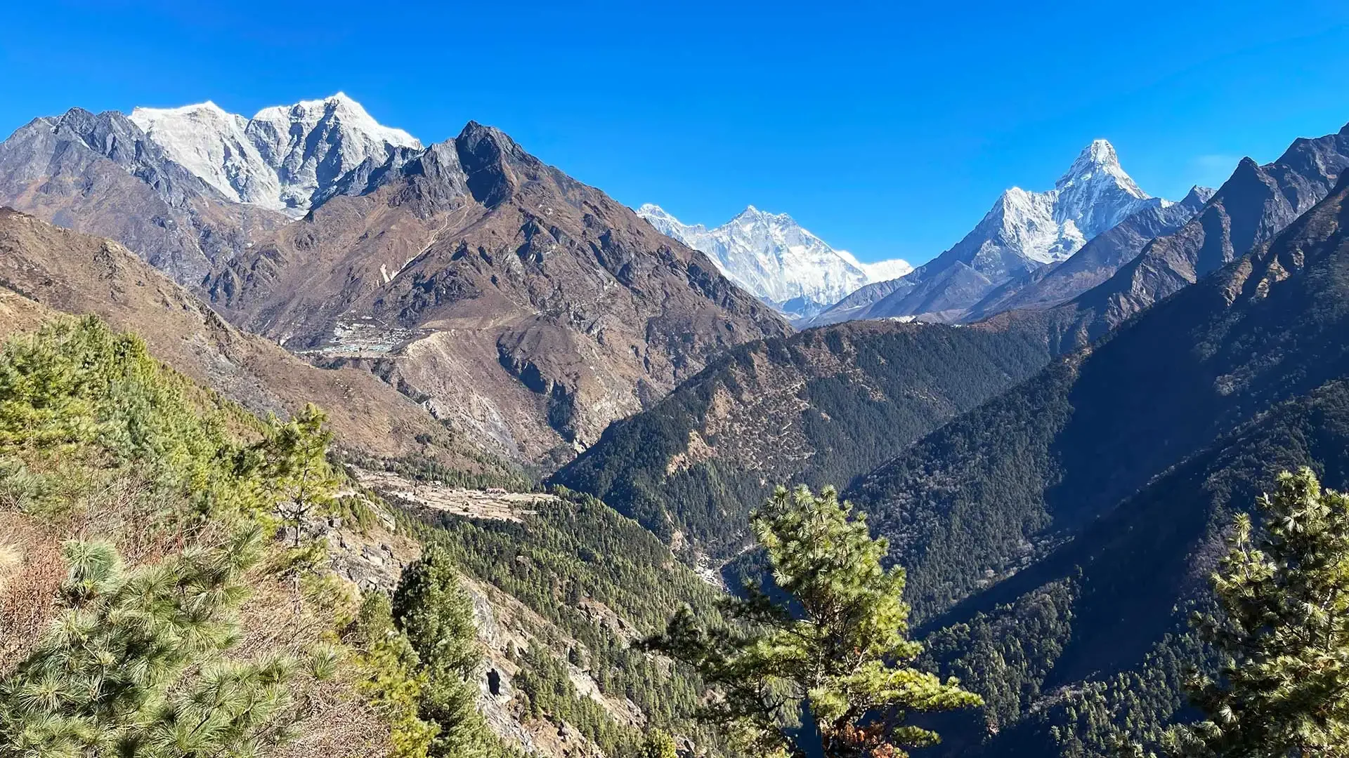
 Khumbu Valley
The Mountains of the Khumbu: Pillars of the Celestial Realm
The mountains of the Khumbu are the defining feature of northeastern Nepal and the primary draw for global tourism. They shape the local geography, dictate the weather patterns, and determine the trekking routes that thousands of visitors navigate annually.
For many, these peaks are the primary reason to visit, offering a concentration of giants found nowhere else on the globe. However, these mountains are far more than just climbing objectives or scenic backdrops for photography.
They are an integral part of the Sherpa identity, interwoven with local religion, folklore, and the daily struggle for survival. The mountains are often viewed as the physical manifestations of powerful deities who must be respected and appeased.
The Four 8,000-Meter Peaks
The Khumbu region contains four of the fourteen mountains in the world that rise above the 8,000-meter mark. These mountains exist in the "death zone," where oxygen levels are too low to sustain human life for more than a few days without bottled support.
Mount Everest (8,848.86 meters): The highest mountain on Earth and a symbol of human endurance. Called Sagarmatha by Nepalis and Chomolungma by Tibetans, the peak is considered a living goddess by the local population. The summit marks the highest point of the terrestrial crust and serves as the ultimate goal for the world's elite mountaineers.
Lhotse (8,516 meters): The fourth-highest mountain in the world, connected to Everest via the South Col. The massive Lhotse Face is a sheer wall of blue ice that climbers must scale to reach the higher camps of the Everest route. Its South Face is one of the most daunting technical walls in the world, rising over 3,200 meters in a near-vertical sweep.
Makalu (8,485 meters): The fifth-highest mountain, located southeast of Everest. It is famous for its isolated, four-sided pyramid shape and its sharp, wind-whipped ridges that stand out against the horizon. It is often cited as one of the hardest 8,000-meter peaks to climb due to its steepness and technical rock sections.
Cho Oyu (8,188 meters): The sixth-highest mountain, marking the western border of the Khumbu. Its name translates to "Turquoise Goddess," a reference to the ethereal color of the light reflecting off its high-altitude glaciers. It dominates the skyline of the Gokyo region, providing a massive white backdrop to the turquoise lakes.
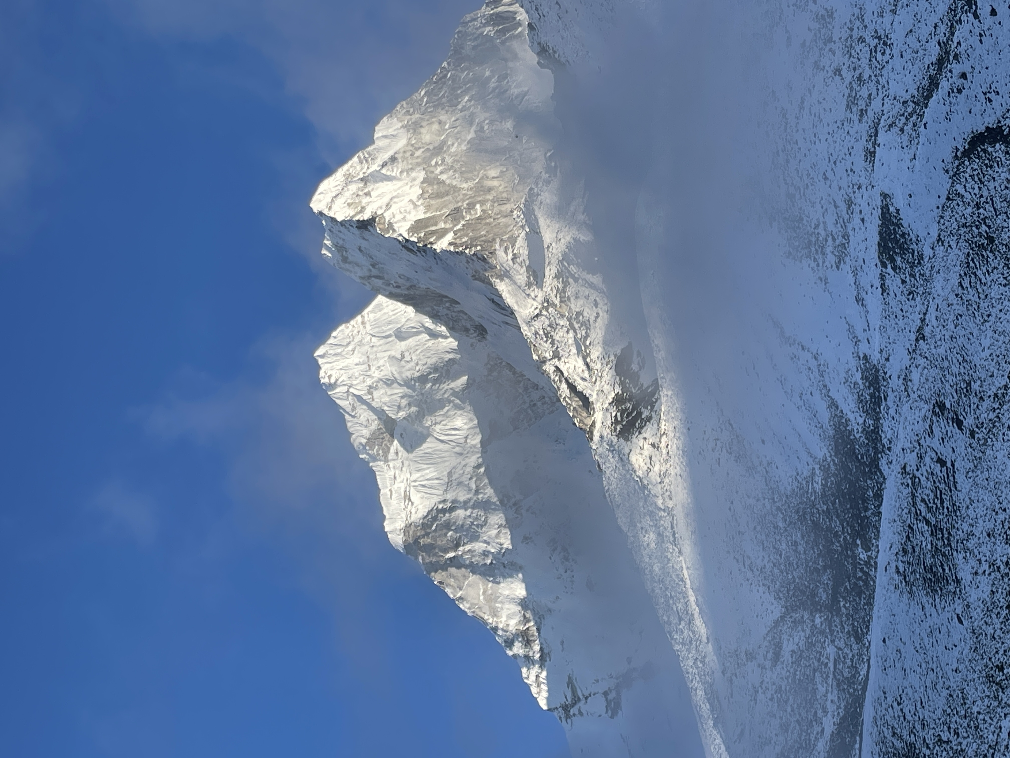 Glorious view of Mt. Ama Dablam
Other Significant Technical Peaks
Beyond the 8,000-meter giants, several other mountains define the aesthetic beauty and technical challenge of the Khumbu. These peaks are often more visually striking to trekkers because of their unique shapes and proximity to the main trails.
Ama Dablam (6,812 meters): Frequently cited as the most beautiful mountain in the world. Its name translates to "Mother’s Necklace," with its ridges appearing like protective arms and its hanging glacier resembling a traditional pendant. It is a highly technical climb involving steep ice, rock, and vertical snow sections that require advanced mountaineering skills.
Nuptse (7,861 meters): Forms the western wall of the Everest massif and creates a massive, jagged ridge. From many viewpoints, Nuptse actually appears higher than Everest due to its dramatic vertical prominence and proximity to the viewer. The mountain is notorious for its avalanche risk and difficult approach through the lower Khumbu Glacier area.
Pumori (7,161 meters): Known as the "Daughter of Everest," standing directly across from the main massif. It provides one of the most photogenic mountain backdrops for trekkers staying at the high-altitude settlement of Gorak Shep. It is frequently used as a training peak for mountaineers preparing for the rigors of an 8,000-meter expedition.
Thamserku (6,608 meters) and Kangtega (6,782 meters): These peaks dominate the eastern skyline above Namche Bazaar. Their fluted ice walls and sharp summits are among the first high peaks trekkers see upon entering the upper Khumbu. Thamserku, in particular, is considered a very difficult technical climb that is rarely attempted compared to its neighbors.
Glacial Systems: The Frozen Architecture
Glaciers are the primary architects of the Khumbu, moving millions of tons of ice and pulverized rock every year. The Khumbu Glacier is the highest glacier in the world and serves as the primary drainage for the entire Everest massif.
It begins in the Western Cwm, a high-altitude basin at approximately 7,600 meters known as the "Valley of Silence." As it flows downward, it creates the world-famous Khumbu Icefall, a labyrinth of shifting ice towers and bottomless, hidden crevasses.
Detailed Facts on the Glacial Environment:
The Khumbu Icefall Movement: The icefall moves at a rate of roughly 0.9 to 1.2 meters per day. This movement makes the terrain incredibly unstable, requiring "Icefall Doctors" to fix ladders and ropes daily during the climbing season. A single collapse of an ice tower can release thousands of tons of debris, making this the most feared segment of the Everest ascent.
Glacial Moraines: Massive ridges of rock and soil pushed aside by the movement of the ice. Trekkers spend days walking along these moraines, which provide a window into the geological power of moving ice over centuries. The unstable nature of these rock piles makes trail maintenance a constant challenge for local communities.
Climate Change and Thinning: Glaciers here are thinning and retreating at an accelerating rate. Scientists use the Khumbu Glacier to track global temperature shifts, noting that the "snow line" is steadily moving higher each decade. This retreat leads to the formation of supraglacial lakes, which pose a significant risk of flooding to the valleys below.
The Ngozumpa Glacier: The longest glacier in the Himalayas, located in the Gokyo Valley. It stretches for nearly 36 kilometers and is covered in a thick layer of rock and debris that hides the massive ice core beneath. It is slowly melting, creating a series of expanding lakes that change the local geography every summer.
Sagarmatha National Park: A Global Sanctuary
Sagarmatha National Park is a UNESCO World Heritage site that encompasses the entire upper Khumbu region. Established in 1976, it protects over 1,200 square kilometers of some of the most fragile and unique ecosystems on the planet.
The park is a global model for how to integrate environmental conservation with indigenous human livelihoods. The Sherpa people are active participants in park management, ensuring that tourism does not erode the natural or cultural fabric of their home.
Protected Features and Management Facts:
UNESCO Designation: Listed as a World Heritage Site in 1979 for its "exceptional natural beauty." This status helps attract international funding and expertise for conservation and infrastructure projects within the region. It also mandates strict regulations on building heights, waste management, and the protection of endangered species.
Conservation Philosophy: A "living" park where people and nature coexist. Unlike many parks that exclude human habitation, Sagarmatha integrates dozens of Sherpa villages into its management plan. This ensures that traditional land-use practices, such as yak grazing, are maintained alongside modern conservation.
Ecosystem Protection: Preventing deforestation and soil erosion through strict fuel regulations. The park has strict rules against cutting down trees for fuel, encouraging the use of solar and hydroelectric energy instead. Reforestation projects are visible throughout the lower valleys, aiming to restore the ancient pine and hemlock forests.
Buffer Zone Programs: Reinvesting tourism revenue into local development. A significant portion of the park entry fees is used to fund local schools, clinics, and clean water projects for the Sherpa community. This creates a direct incentive for the local population to protect the environment that attracts visitors.
More on: A Complete Guide to Sagarmatha National Park
Biodiversity: Life at the Edge of the Atmosphere
Despite its harsh conditions, Khumbu supports diverse ecosystems due to its massive altitude range. Life here has evolved specialized mechanisms to handle extreme cold, high UV radiation, and low oxygen.
The vegetation changes dramatically as one moves from the valley floors to the high passes. This transition creates distinct habitats for a variety of rare and endangered Himalayan wildlife.
Flora and Vegetation Zones:
Lower Elevations (2,800–3,500m): Dense forests of Blue Pine, Hemlock, and Himalayan Fir. In the spring, these forests are transformed by the bloom of the Rhododendron, which is Nepal’s national flower. The forest floor is rich with ferns and mosses, sustained by the moisture trapped within the deep river gorges.
Middle Elevations (3,500–4,500m): Transition to Juniper, Birch, and stunted Fir. As the trees become smaller due to the wind and cold, the forest gives way to alpine shrubs and vast grasslands. These areas are critical grazing lands for yaks and provide a habitat for the shy and endangered Musk Deer.
High Elevations (Above 4,500m): The Arctic Tundra of the Sky. Above the "tree line," only the hardiest lichens, mosses, and cushion plants can survive the extreme conditions. The landscape becomes a world of rock and ice, yet even here, tiny wildflowers bloom during the brief summer window.
Wildlife of the Khumbu:
The Snow Leopard: The "Ghost of the Mountains" and the apex predator of the region. This elusive cat is perfectly camouflaged against the rocky crags and preys on the Himalayan Tahr and Musk Deer. While sightings are extremely rare, their presence indicates a healthy, functioning high-altitude ecosystem.
The Himalayan Monal (Danphe): A spectacular bird with iridescent nine-colored plumage. As the national bird of Nepal, the Monal is a frequent sight in the forests around Namche Bazaar and Tengboche. Its colorful feathers shimmer in the high-altitude sun, making it one of the most sought-after sights for birdwatchers.
The Himalayan Tahr: A large mountain goat with a thick, shaggy coat and backward-curving horns. They are often seen in large groups grazing on the near-vertical cliffs above the Dudh Koshi River. Their ability to maneuver on steep rock faces is a remarkable adaptation to the rugged terrain of the Khumbu.
Birds of Prey: Including the Bearded Vulture (Lammergeier) and the Golden Eagle. These massive birds are often seen soaring on the thermals generated by the deep mountain valleys. They play a vital role in the ecosystem by scavenging on the remains of animals that perish in the harsh winters.
Sherpa Culture: History, Biology, and Tradition
The Sherpas are an ethnic group that migrated from the Kham region of Tibet roughly 500 years ago. Their name literally translates to "Easterners," reflecting their historical origins and their migration across the high passes.
They have developed a unique and fascinating physiological adaptation to life at high altitude. Centuries of living above 3,000 meters have resulted in genetic traits that allow for more efficient oxygen utilization at the cellular level.
Key Cultural and Biological Facts:
Genetic Adaptation: Sherpas possess a unique metabolic efficiency that lowlanders do not have. Research shows their bodies use oxygen more effectively at the mitochondrial level, preventing the "thickening" of blood common in visitors. This allows them to perform strenuous physical labor at altitudes where others can barely walk.
The Sherpa Language: A dialect of Tibetan with its own unique vocabulary and nuances. While many younger Sherpas speak Nepali and English, the local language is still used for daily life and religious ceremonies. Preserving the language is seen as a vital part of maintaining their distinct cultural identity in a globalized world.
Social Structure: Traditionally organized around clans and extended families. The Sherpa community is known for its egalitarian nature and the high social status traditionally afforded to women. Decision-making is often communal, centered around the village monastery or the advice of respected elders.
Economic Transition: From trans-Himalayan salt traders to adventure tourism experts. Until the 1950s, Sherpas dominated the trade routes between Tibet and the middle hills of Nepal. The closure of the border and the rise of mountaineering shifted their economy toward providing elite services to climbers.
Spiritual Heritage: The Living Buddhism of the Valleys
Buddhism permeates every single aspect of life and landscape within the Khumbu region. The trails are dotted with Mani walls, prayer flags, and Chortens that serve as spiritual landmarks for locals and visitors alike.
Mani walls are constructed from thousands of flat stones carved with the sacred mantra "Om Mani Padme Hum." Tradition dictates that travelers should always pass these structures on the left side to maintain the proper flow of spiritual energy.
Religious Landmarks and Traditions:
Tengboche Monastery: The spiritual heart of the region, perched on a high ridge at 3,867 meters. It is the largest Gompa in the Khumbu and offers one of the most famous views of Mount Everest and Ama Dablam. The monastery serves as the primary educational center for monks and the site of the most important annual festivals.
The Mani Rimdu Festival: The most significant event in the Sherpa cultural calendar. Held annually at Tengboche, it involves nineteen days of meditation followed by three days of public festivities. The highlight is the masked dances performed by monks to symbolize the victory of Buddhism over ancient spirits.
Prayer Flags (Lung-ta): The five colors represent the elements: blue (sky), white (air), red (fire), green (water), and yellow (earth). They are placed on high ridges and bridges to bless the surrounding area and carry prayers on the wind. As the flags fade and fray, it is believed the prayers are released into the universe.
The Puja Ceremony: A vital ritual performed before any major climbing expedition. Climbers and Sherpas gather before a stone altar to offer food, drink, and incense to the mountain deities. It is a request for safe passage and a way to show respect to the spirits of the high peaks.
 Tengboche Monastery
Major Villages: The Hubs of Himalayan Civilization
The villages of the Khumbu are remarkable examples of human ingenuity and high-altitude urban planning. They serve as vital rest stops for thousands of trekkers and as permanent, thriving homes for the Sherpa people.
Each village has a distinct character and plays a specific role in the trekking and climbing economy.
Namche Bazaar (3,440 meters): The undisputed administrative and commercial capital of the entire Khumbu. Built into a natural horseshoe-shaped amphitheater, it features ATMs, Irish pubs, and high-speed internet. It is the mandatory acclimatization stop, where all travelers spend at least two nights to allow their bodies to adjust.
Lukla (2,860 meters): The primary entry point for almost all visitors to the region. It is home to the Tenzing-Hillary Airport, which is famous for its short and steeply sloped runway. The town is a bustling hub of porters, yaks, and helicopters, marking the beginning and end of most Everest adventures.
Khumjung and Khunde (3,780 meters): Located in a high valley directly above the busy streets of Namche. These villages are more traditional, featuring green-roofed stone houses and the school founded by Sir Edmund Hillary. Khumjung Monastery famously claims to house a Yeti scalp, a testament to the local folklore that enriches the region.
Pheriche and Dingboche (4,200+ meters): The final major settlements before reaching the stark terrain of Base Camp. Dingboche is known for its stone walls that protect crops of barley and buckwheat from the high-altitude winds. Pheriche houses the Himalayan Rescue Association clinic, providing life-saving medical care to those with altitude sickness.
Thame (3,800 meters): A historic village located on the ancient trade route toward the Nangpa La pass. It is the home of many famous climbers, including Tenzing Norgay and Apa Sherpa, who has summited Everest 21 times. The village feels more remote and traditional than the main Everest Base Camp trail.
 Lukla Airport
Trekking Routes: The Paths to High Adventure
The Khumbu offers a variety of trekking routes that cater to different levels of fitness and ambition. Each path provides a unique perspective on the mountains and a different degree of cultural immersion.
Summary of Popular Trekking Routes:
The Everest Base Camp (EBC) Trek: The most famous trek in the world, taking 12 to 14 days. It follows the traditional approach route, ascending through Namche, Tengboche, and Lobuche to the base of the world's highest peak. The highlight is standing at 5,364 meters at the edge of the Khumbu Icefall.
The Gokyo Lakes Trek: A stunning alternative that leads travelers into the western valley of the Khumbu. It focuses on a series of six turquoise glacial lakes, which are among the highest freshwater systems in the world. The ascent of Gokyo Ri offers a panoramic view of four 8,000-meter peaks simultaneously.
The Three Passes Trek: The ultimate high-altitude challenge, connecting the three main valleys. Trekkers cross the Kongma La (5,535m), Cho La (5,420m), and Renjo La (5,360m) passes. This loop offers the most complete geographical overview of the region, away from the main commercial arteries.
The Everest Panorama Trek: A shorter 5 to 7 day trek for those with limited time. It goes as far as Tengboche, offering incredible views of Everest and Ama Dablam without the risk of extreme altitude. It is ideal for families or those who want a taste of Sherpa culture without a multi-week commitment.
The Four Seasons: A Climatic Cycle
The timing of a visit to the Khumbu is dictated by the distinct seasonal cycles of the Himalayas. Each season offers a different landscape, set of challenges, and atmospheric quality.
Detailed Seasonal Breakdown:
Spring (March to May): The primary season for mountaineering expeditions. The weather is generally stable, and the lower forests are alive with blooming rhododendrons. However, the trails are at their busiest, and the afternoons can often become cloudy and hazy.
Autumn (September to November): Widely considered the best time for trekking. After the monsoon rains, the air is crystal clear, offering the most spectacular and crisp mountain views. The weather is very stable, though this is the most crowded time to visit the region.
Winter (December to February): A time of intense cold and brilliant, sun-drenched days. Night temperatures frequently drop to -20°C, and many high passes are closed by deep snow. The advantage is the total absence of crowds, but it requires high-quality gear and a high tolerance for cold.
Summer/Monsoon (June to August): Characterized by heavy rains, thick clouds, and leeches. The mountains are rarely visible, and flights to Lukla are frequently cancelled due to poor visibility. However, the landscape is incredibly green and lush, and the agricultural life of the Sherpas is in full swing.
Infrastructure and Modern Challenges
Operating in the Khumbu presents massive logistical hurdles due to the total lack of roads. Everything, from building materials to jars of coffee, must be transported by human or animal power.
The region's infrastructure is a delicate balance of ancient tradition and modern necessity.
Logistical and Environmental Facts:
The Role of the Porter: The unsung heroes of the high-altitude economy. Porters often carry loads exceeding 60 kilograms, using traditional "namlo" head-straps to distribute the weight. Modern regulations have improved their pay and working conditions, though the job remains one of the most physically demanding on Earth.
The Helicopter Economy: A vital safety net for medical evacuations and high-end logistics. In recent years, helicopter traffic has surged, bringing fresh food and luxury goods to remote lodges. While efficient, the noise and frequency of flights have become a point of environmental and aesthetic concern for some.
Waste Management Initiatives: Combating the "highest junkyard" reputation. Groups like the Sagarmatha Pollution Control Committee (SPCC) work to remove tons of waste from Everest and the trails. Trekkers are now encouraged to "Carry Me Back" small bags of trash to be properly processed in Lukla.
Energy and Sustainability: Transitioning away from wood toward renewable energy. Most tea houses now use solar panels for lighting and charging electronic devices for trekkers. Micro-hydroelectric plants in Namche and Khumjung provide clean power to homes and businesses, reducing the pressure on local forests.
Conclusion: The Heart of Himalayan Adventure
The Khumbu Region is far more than just a collection of the world's highest peaks. It is a testament to the resilience of the human spirit and the majesty of the natural world.
For the traveler, it offers a profound journey into a landscape that demands humility and provides inspiration. For the Sherpa, it remains a sacred home that they protect and share with the rest of humanity with grace and pride.
Whether standing at the base of Everest or inside a quiet monastery, the Khumbu leaves an indelible mark on all who visit. It is, and will always be, the true heart of Himalayan heritage and adventure.