Sagarmatha National Park: Where the Earth Reaches the Sky
Published Thu Feb 26 2026
Sagarmatha National Park is the home of Mount Everest along with Nuptse, Lhotse, and other big mountains. Learn all about the region in this article.
There is a checkpoint just outside the village of Monjo, a couple of days walk north of Lukla, where a ranger sits in a small stone building and checks your permits before waving you through a gate. On the other side of that gate, the trail continues through pine forest toward Namche Bazaar, and the mountains ahead get bigger with every bend.
That gate marks the entrance to Sagarmatha National Park, and passing through it feels like crossing into somewhere that operates by different rules. Bigger rules. Older ones.
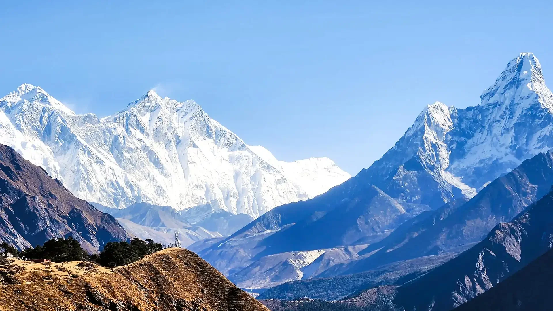
Sagarmatha National Park is located in the Solukhumbu District of northeastern Nepal, tucked into the upper Khumbu region along the border with Tibet. It covers 1,148 square kilometers of some of the most extreme terrain on the planet, from deep river gorges cut by glacial meltwater to the highest summit on earth.
If you have ever asked where Sagarmatha National Park is located, the simplest answer is this: it sits at the top of Nepal, and at the top of the world.
A Name With Weight
The park takes its name from the Nepali word for Mount Everest. "Sagar" means sky, "matha" means head. Head of the sky. It is an almost offensively accurate description for a mountain that stands at 8,848.86 meters and can be seen from aircraft cruising at high altitude.
The Tibetan name, Chomolungma, carries equal poetry. But it is Sagarmatha that this park, this landscape, and this entire protected region are named for, and rightly so.
The park was established in 1976, making it one of the oldest formally protected areas in Nepal. Just three years later, in 1979, it was designated a UNESCO World Heritage Site, recognizing its value not just as a natural landscape but as a place of profound cultural significance.
When was Sagarmatha National Park established? 1976. That is nearly fifty years of formal protection for a place people have been living in and traveling through for centuries.
 Sagarmatha National Park
Where Exactly Is It, and How Do You Get There
The Sagarmatha National Park location sits at the coordinates of roughly 27 to 28 degrees north latitude and 86 to 87 degrees east longitude, deep in the Solukhumbu District. For practical purposes, the park entrance is at Monjo, a small village at 2,840 meters that most trekkers pass through on day two of the classic Everest Base Camp route.
How to reach Sagarmatha National Park from Kathmandu follows a well-worn path. You fly from Tribhuvan International Airport in Kathmandu to Tenzing-Hillary Airport in Lukla, a flight of roughly 35 minutes that delivers you to an airstrip carved into a Himalayan hillside at 2,860 meters. From Lukla, you walk. Most trekkers reach the park entrance at Monjo on their second day of hiking. There is no road access. The walk is the access.
For those with a different budget or a tighter schedule, there is a helicopter option. Sagarmatha National Park helicopter transfers from Kathmandu or from Lukla exist and can deposit you at various points along the route, including directly at Everest Base Camp for day trips.
They are expensive, weather-dependent, and bypass much of the experience. Most people who take the helicopter wish they had walked, at least part of the way.
 Sagarmatha National Park Khumbu Region
Permits, Fees, and Paperwork on Sagarmatha National Park
Before you pass through that checkpoint at Monjo, you need to have your documents in order. The Sagarmatha National Park entry permit is mandatory for all foreign visitors. As of recent years, the Sagarmatha National Park entry fee for foreign nationals sits at around 3,000 Nepalese rupees per person, though this figure is subject to periodic revision and you should confirm the current rate before your trip.
The Sagarmatha National Park permit is issued at the park entrance checkpoint in Monjo, or you can obtain it in Kathmandu through the Department of National Parks and Wildlife Conservation office. Many trekkers also handle permits through their trekking agency as part of a packaged Sagarmatha National Park tour.
In addition to the park entry fee, you will also need a TIMS card (Trekkers' Information Management System) if trekking independently.
There are also Sagarmatha National Park tickets for specific permits, including fees for climbing expeditions, which are a separate and considerably more expensive category. For regular trekkers doing the EBC route or other trails within the park, the standard entry permit and TIMS card cover everything.
A note on commercial photography: commercial photography permit requirements for Sagarmatha National Park apply to film crews and professional productions. If you are a documentary filmmaker or are shooting for commercial use, you will need to apply for a separate permit through the relevant government office in Kathmandu.
For personal photography, no additional permit is required, and the park offers extraordinary opportunities for Sagarmatha National Park photos at every elevation.
The Landscape: What the Map Shows and What It Cannot
A Sagarmatha National Park map shows you the trails, the villages, the glaciers, the rivers, and the peaks. What it cannot show you is the way the landscape changes as you climb through it. The park spans an elevation range from 2,845 meters at Monjo to 8,848.86 meters at the Everest summit, and that vertical range contains more ecological variation than most countries see horizontally.
The Sagarmatha National Park elevation range is one of the defining facts about the place. At the bottom, you are in temperate forest. Pine, fir, birch, juniper, rhododendron. In spring, the rhododendron blooms light the lower trails in deep pink and red.
Gradually the trees thin, the shrubs take over, then the shrubs give way to alpine meadow and rock. Above a certain point, nothing grows. Then there is only ice.
The park's coordinates place it along the southern flanks of the Greater Himalayas, with the Dudh Koshi River draining its lower valleys and the Khumbu Glacier occupying the high terrain above Gorak Shep. The glacier alone, which feeds into the famous Khumbu Icefall above Base Camp, is one of the most studied glacial systems on the planet.
Its retreat over recent decades is one of the clearer visible signs of climate change in the region.
Sagarmatha National Park Flora and Fauna
The biodiversity here surprises many visitors who arrive expecting only rock and ice. Sagarmatha National Park flora and fauna are remarkably rich given the altitude and conditions, particularly in the lower and middle elevation zones.
In the forests below Namche, you can encounter musk deer, Himalayan tahr, and the occasionally spotted red panda moving through rhododendron cover. The snow leopard exists in the park but is rarely seen, a ghost of the high ridges that most trekkers will never encounter despite sharing the landscape with it.
The Himalayan monal, Nepal's national bird and a bird of genuinely spectacular plumage, is more frequently spotted and a genuine thrill when it appears on a trail-side boulder.
Above the treeline, the fauna shifts. Himalayan gorals, a type of mountain goat, pick their way across impossibly steep slopes. Yellow-billed choughs wheel and call above Base Camp. The landscape feels empty until you learn to look more carefully, and then it feels very much alive.
The Sherpa World Inside the Park
Walking through Sagarmatha National Park is not like walking through an uninhabited wilderness reserve. People live here. The Sherpa communities of Namche Bazaar, Khumjung, Phakding, Pangboche, and dozens of smaller settlements have occupied this high-altitude landscape for centuries, building their lives around farming, herding, trade, and increasingly, mountaineering and tourism.
Namche Bazaar, at 3,440 meters, is the commercial and social hub of the Khumbu. It has a Saturday market that draws villagers from across the region, and its main street now holds bakeries, gear shops, espresso cafes, and well-stocked pharmacies that would not look out of place in a mountain town in Switzerland.
The Sagarmatha National Park office for the region operates from Namche, and many trekking agencies have offices here as well.
Higher up, the villages are quieter. Tengboche Monastery, the largest in the Khumbu, sits on its famous ridge above the treeline with Ama Dablam behind it and prayer flags strung across the courtyard. Pangboche, further up the valley, is one of the oldest Sherpa villages in the region.
Dingboche and Lobuche, at over 4,400 meters, are essentially high camp villages that exist primarily to support EBC trekkers and climbers. The Sherpa culture threads through all of it, in the mani walls along the trails, in the prayer wheels at every village entrance, in the way the teahouse owners know which direction the weather is moving before any forecast does.
 A Lodge in Lobuche inside Sagarmatha National Park
Temperature and What to Expect Seasonally
The Sagarmatha National Park temperature varies dramatically by elevation, season, and time of day. At Namche Bazaar in October, daytime temperatures might reach a pleasant 12 degrees Celsius, while nights drop to near freezing. At Everest Base Camp at 5,364 meters, even in the warmest months, nighttime temperatures regularly fall to minus 15 degrees Celsius or colder. Wind chill makes the real felt temperature considerably lower.
The best windows for visiting are spring (March to May) and autumn (September to November). Spring brings rhododendron blooms and the energy of climbing expeditions preparing for summit attempts. Autumn brings the clearest skies of the year, sharp and cold and perfect for photographs. These are also the two busiest seasons, and the trail between Lukla and Base Camp in October can feel surprisingly crowded.
Winter visits are possible for the well-prepared. The trails are quieter, the teahouses less busy, and the light in December and January has a particular quality that photographers prize. The cold is serious though, and some teahouses at higher elevations close entirely.
Monsoon season (June through August) brings rain to the lower valleys, leeches on the trail, and cloud cover that obscures the peaks for days at a time. A few trekkers deliberately visit in the monsoon for the solitude and the lush, wildly green lower valleys. It is not for everyone.
Trekking in Sagarmatha: The Routes
A Sagarmatha National Park trek can take many forms, from a short acclimatization walk above Namche to a full three-week traverse of multiple high passes. The classic Everest Base Camp trek takes roughly 12 to 14 days round trip from Lukla, passing through the park entrance at Monjo, through Namche, Tengboche, Dingboche, Lobuche, and Gorak Shep before reaching Base Camp at 5,364 meters.
The optional side climb to Kala Patthar at 5,643 meters gives the most famous close-up view of the Everest summit available without technical climbing.
The Gokyo Lakes trek is a popular alternative and combination route. The turquoise lakes at Gokyo sit at around 4,700 to 5,000 meters, and Gokyo Ri at 5,357 meters offers a panorama that many argue surpasses Kala Patthar in variety, with Everest, Cho Oyu, Lhotse, and Makalu all visible simultaneously.
The route sees fewer trekkers than the main EBC trail and feels less like a moving queue.
For strong, experienced trekkers, the Three Passes Trek combines the EBC route with the Gokyo valley and crosses three high passes above 5,000 meters, including Renjo La, Cho La, and Kongma La. It is demanding, requires good fitness and altitude experience, and takes roughly 18 to 21 days. It is also, by most accounts of those who have done it, the finest trekking route in Nepal.
There are also shorter options. Day hikes from Namche to the Hotel Everest View at 3,880 meters or to the Sherpa village of Khumjung make excellent acclimatization excursions that give non-trekkers and those with limited time a genuine taste of the park.
Sagarmatha National Park things to do extend beyond the headline treks: monastery visits, village walks, wildlife watching in the lower forests, and cultural immersion in Sherpa homestays are all part of the experience.
Treks Within Sagarmatha National Park: Your Options at a Glance
The range of organized treks operating entirely or primarily within Sagarmatha National Park is wider than most people realize. Whether you have a week or three, whether you want to stand at Base Camp or simply walk high enough to see Everest clearly from a ridge, there is a route that fits. Here is a closer look at the main options.
The Everest Base Camp Trek in 14 days is the most popular format for this route and the one most trekking agencies lead. Starting and ending with a flight to and from Lukla, it covers around 130 kilometers on foot and tops out at 5,644 meters on Kala Patthar.
It is classified as challenging, not because any individual day is technically difficult, but because the sustained altitude, daily walking, and cumulative fatigue add up.
For those who want the full EBC experience without the return slog down to Lukla on foot, the Everest Base Camp Trek with Heli Return does exactly what it says. You walk in over 12 days, reach Base Camp and Kala Patthar, and then take a helicopter back from Lukla or a higher drop-off point.
It covers around 65 kilometers of trekking in total, significantly less than the full return on foot, and the helicopter ride across the Khumbu offers aerial views of the region that no trail can match.
The Classic Everest Base Camp Trek in 21 days is the unhurried version of the same journey, following the historic route taken by early Everest expeditions. At 185 to 205 kilometers, it is the longest format of the EBC trek and the one that gives you the most time to absorb the landscape, the culture, and the altitude without rushing any of it.
It is the right choice for first-time high-altitude trekkers, anyone who has had altitude issues in the past, or simply people who want more time in the Khumbu rather than less.
The Everest Panorama Trek in 7 days is built for travelers with limited time who still want a genuine Himalayan experience. Topping out at 3,860 meters, it stays below the most demanding altitude zones while still delivering views of Everest, Lhotse, Ama Dablam, and the surrounding peaks from well-positioned ridge viewpoints.
It is classified as moderate and is a realistic option for reasonably fit people who have not trekked at altitude before. You will not reach Base Camp, but you will understand why people keep coming back to this part of the world.
The Gokyo Lakes and Ri Trek in 12 days takes you away from the main EBC corridor and into the quieter western valley of the Khumbu, where a chain of high-altitude glacial lakes sits beneath Cho Oyu, the sixth highest mountain on earth.
The trek covers 90 to 110 kilometers and reaches a maximum altitude of 5,357 meters on Gokyo Ri. The views from that summit are among the best available anywhere in the region, and the relative solitude of the Gokyo valley compared to the EBC trail is something many trekkers specifically seek out.
The Everest Base Camp with Gokyo Lakes Trek in 17 days combines both valleys into a single itinerary, crossing the Cho La pass at roughly 5,420 meters to connect the two routes.
At 145 to 155 kilometers, it is a longer and more demanding undertaking, but it is also the trek that gives you the most complete picture of what Sagarmatha National Park contains. You see the main Everest corridor, the Gokyo lakes, the high passes, and the full sweep of the Khumbu glacial system, all in one continuous journey.
The Everest Three Passes Trek in 19 days is the most technically demanding route in this list. Crossing Renjo La, Cho La, and Kongma La, three passes all above 5,000 meters, over a total distance of 160 to 170 kilometers, it requires solid previous trekking experience and good physical conditioning.
In return, it takes you through remote terrain that the standard EBC trekker never sees, and it gives you a perspective on the scale and geography of the park that no single-valley route can provide.
Finally, the Mera Peak trek in 14 days takes you into the Hinku Valley, a less-visited drainage to the south and east of the main Khumbu corridor, to attempt Mera Peak at 6,461 meters. Mera is classified as a trekking peak in Nepal, meaning it requires crampons, ice axe, and basic mountaineering skills, but does not demand the technical expertise of a full climbing expedition.
It is the highest point most non-technical climbers will ever stand on, and it sits entirely within the boundaries of Sagarmatha National Park. For trekkers looking to cross the line from hiking into actual mountaineering, Mera is one of the most accessible places to do it.
All of these routes share the same entry requirements, the same permit system, and the same essential character. They move through Sherpa villages, past monasteries and mani walls, across rivers and moraines, and always upward toward the high peaks that define this corner of the planet.
Sagarmatha National Park Hotels and Accommodation
Sagarmatha National Park hotels is a slightly misleading category, because accommodation inside the park mostly takes the form of teahouses rather than conventional hotels. These are family-run guesthouses that provide a bed, usually a simple room with two to four narrow beds and thin walls, and meals centered on dal bhat, noodle soup, and increasingly, pasta and pizza at the more tourist-heavy stops.
The quality of teahouses improves considerably at the main trekking hubs. Namche Bazaar has several comfortable lodges with heated common rooms, hot showers (often solar-powered), and reliable wifi. Dingboche and Lobuche have more basic options, and by the time you reach Gorak Shep, the options are limited and the plumbing is minimal. This is part of the deal.
Booking teahouses in advance was historically unnecessary, with trekkers simply turning up and finding space. The increase in visitor numbers over the past decade has made advance booking advisable during peak season in October.
Various online platforms and trekking agencies now offer Sagarmatha National Park tour packages that include accommodation booking along the route.
Conservation: The Real Challenge
The numbers tell part of the story. In 1979, the park received around 3,600 visitors. Recent years have seen roughly 40,000 trekkers and climbers entering annually. That is a tenfold increase, and the landscape and communities are feeling it.
Waste management is the most visible issue. The trails between Lukla and Base Camp carry the literal weight of decades of poorly managed tourism waste, and while major clean-up expeditions have removed tonnes of garbage from the upper mountain and the lower trails, the problem is ongoing.
The Sagarmatha National Park rules increasingly require trekkers to carry out their own non-biodegradable waste, and there are penalties for littering within the park boundaries.
Firewood consumption was historically a serious deforestation problem, largely addressed now through the introduction of kerosene and gas cooking in teahouses and the expansion of micro-hydropower in the Khumbu villages. The lower forests around Phakding and Monjo are noticeably recovering compared to photographs from the 1980s.
Climate change presents a longer and less tractable challenge. The glaciers are retreating visibly. The Khumbu Glacier has lost significant volume over the past several decades, and the impacts on downstream water availability for communities across Nepal are a legitimate and growing concern.
The buffer zone that surrounds the core protected area, roughly 275 square kilometers of additional managed landscape, helps extend conservation beyond the park boundaries and provides revenue-sharing mechanisms that bring income into local communities. It is not a perfect system, but it represents a genuine attempt to balance protection with the economic realities of a region whose primary income is now tourism.
Why It Still Matters
After everything, after the crowds and the permits and the teahouse pasta and the carefully managed acclimatization schedules, Sagarmatha National Park still does what it has always done. It puts you in the presence of something that makes human concerns feel temporarily smaller and more manageable in proportion.
The park is not just a backdrop for adventure tourism or a bucket-list destination for tick-box trekkers. It is a living landscape that has shaped the culture, faith, and identity of the Sherpa people for generations. It is a scientific site of global importance for climate and glaciological research.
It is one of the few places on the planet where you can walk from temperate forest through alpine meadow to the edge of the highest mountain on earth, all under your own power, in under two weeks.
Travel responsibly when you go. Carry your rubbish out. Respect the Sagarmatha National Park rules, which exist for good reason. Hire local guides and porters. Eat at Sherpa-run teahouses.
Give the park what it needs to remain what it is, and it will give you something that most landscapes simply cannot.